Abstract
This article introduces the integration of the Septentrio AsteRx-m3 pro high-precision GNSS receiver with the ArduPilot flight controller. The AsteRx-m3 pro brings industrial-grade AIM+ anti-jamming and anti-spoofing technology, centimeter-level RTK positioning, real-time dual-antenna heading, and full-constellation frequency support to open-source flight control systems. With a 100 Hz update rate, ultra-low power consumption, and compact design, this combination significantly enhances operational accuracy, system reliability, and autonomous capabilities in demanding professional applications such as power line inspection, surveying, and precision agriculture.
High-Precision GNSS Positioning Empowering Drone Flight Control Systems
In complex electromagnetic environments and demanding operational scenarios, the Septentrio AsteRx-m3 pro high-precision GNSS receiver provides a stable and trustworthy positioning and heading core for drone systems based on open-source flight controllers like ArduPilot and PX4. With its exceptional anti-jamming and anti-spoofing technology, dual-antenna heading capability, and centimeter-level RTK positioning, this receiver enables drones to achieve precision hovering and high-accuracy trajectory tracking during power line inspection, precision surveying, and other critical missions.
Challenges of GNSS in Drone Flight Control Systems
GNSS Positioning Integrity Failure Challenge
This refers to the flight control system’s inability to trust GNSS outputs at critical decision points. Under spoofing attacks, malicious GNSS signals can forge entirely plausible but false positioning, velocity, and time information without warning, potentially causing the drone to collide with assets under inspection, deviate into unsafe areas, or perform “ghost hovering” over locations that are not actually safe. Under complex interference, broadband electromagnetic noise from high-voltage lines or substations can saturate standard receivers, leading to complete loss of signal tracking.
Availability and Stability Challenges of RTK Positioning
During close-range precision operations, GNSS must provide continuous, high-precision positioning. Dynamic disturbances from multipath and signal occlusion — when drones maneuver between structures like transmission towers or buildings — cause signal reflections that can produce positioning “jumps” of tens of centimeters. Such jumps are fatal for operations requiring centimeter-level stability such as automatic hovering or precise path following. Additionally, excessive baseline length to the base station or loss of lock due to interference directly causes the flight controller to lose high-precision positioning input.
GNSS Signal Quality and Fusion Challenges in Dynamic Environments
GNSS is the core of multi-sensor fusion navigation for drones. Transient electromagnetic pulses from switching arcs or discharges can cause short-term “blinding” of the GNSS receiver. Rapid environmental changes during inspections — such as flying from open space into areas near high-voltage lines — require the flight controller to dynamically assess GNSS confidence and smoothly switch between GNSS, vision, and inertial navigation modes.
Core Advantages of the Septentrio AsteRx-m3 pro
Top-Tier Anti-Jamming and Anti-Spoofing — AIM+ Technology
AIM+ (Advanced Interference Mitigation) is Septentrio’s industry-leading anti-jamming and anti-spoofing technology, featuring unique hardware and adaptive digital filtering. It effectively counters pulsed interference, broadband swept-frequency interference, narrowband interference, and pseudolite interference. The built-in RF spectrum monitoring system detects and locates interference sources in real time. In independent tests at Norway’s JammerTest facility, the AsteRx-m3 pro maintained 99.5% positioning availability under strong interference, outperforming most competitors.
Full Constellation, Full Frequency Support with RTK Performance
Supports GPS, GLONASS, BeiDou, Galileo, QZSS, NavIC, and SBAS with reliable centimeter-level RTK accuracy:
- Horizontal accuracy: 0.6 cm + 0.5 ppm
- Vertical accuracy: 1.0 cm + 1 ppm
- Dual-antenna mode providing high-precision heading and pitch/roll without magnetic sensors
Ultra-Low Power Consumption and Compact Design (Optimal SWaP)
- Lowest power consumption in its class: 1000 mW in full constellation, all-frequency mode
- Dimensions: 47.5 x 70 x 9.32 mm, weight: 27 g
- Suitable for embedded applications with strict size, weight, and power (SWaP) requirements
GNSS+ Algorithm Suite Ensures Stability in Complex Environments
- LOCK+ — Maintains stable tracking under high vibration and shock
- IONO+ — Mitigates the impact of ionospheric scintillation on signals
- APME+ — Effectively suppresses multipath effects, improving observation quality
- RAIM+ — Receiver Autonomous Integrity Monitoring enhances system reliability
Easy Integration and Operation
- Complete interface documentation, command sets, SDK, and RxTools configuration software
- Web UI for remote configuration and status monitoring
- Compatible with SBF, NMEA, RTCM, CMR formats and serial, USB, Ethernet, NTRIP interfaces
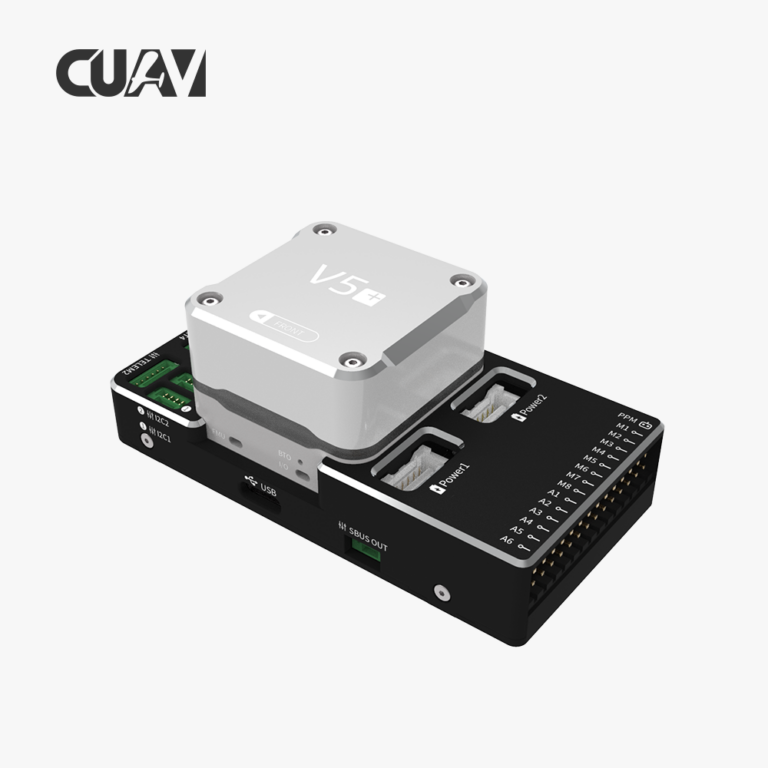
Integration Advantages with ArduPilot
RTK Positioning and Attitude Output Enhance Flight Control Precision
The AsteRx-m3 pro supports centimeter-level RTK positioning (horizontal: 0.6 cm + 0.5 ppm) and dual-antenna heading/attitude output (heading accuracy up to 0.03°, pitch/roll accuracy 0.05°). ArduPilot can directly use this high-precision position, velocity, and heading information to achieve more stable hovering, precise route tracking, and automated takeoff and landing.
Powerful Anti-Jamming Capabilities Enhance System Reliability
Integrated AIM+ anti-jamming and anti-spoofing effectively suppresses swept-frequency interference, pulsed interference, and spoofing signals, ensuring stable positioning data output even near high-voltage lines and substations. For drones operating in urban areas, airports, and industrial zones with numerous interference sources, this system significantly reduces the risk of loss of control due to GNSS signal loss or jumps.
High Update Rate and Low Latency for High-Dynamic Flight
Supports a 100 Hz position update rate with sub-20 ns event marker accuracy, providing ArduPilot with high-frequency, low-latency positioning input suitable for high-speed drones, autonomous obstacle avoidance, and agile maneuvering.
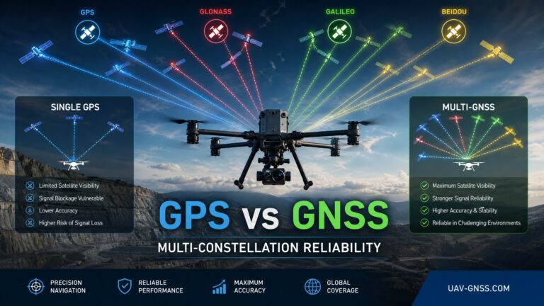
Full Constellation, Full Frequency GNSS for Maximum Satellite Availability
Tracking all major constellations and frequencies significantly increases the number of visible satellites, maintaining higher positioning availability in occluded environments such as urban canyons and forests and reducing the likelihood of ArduPilot degrading positioning modes due to insufficient satellite count.
PPK and Post-Processing Support for Survey-Grade Data
The SDK and post-processing libraries support PPK (Post-Processed Kinematic) mode, which can be combined with ArduPilot’s logging system to provide higher-precision trajectory data for aerial survey and 3D modeling tasks.
Building Professional-Grade Autonomous Systems
The combination of AsteRx-m3 pro and ArduPilot provides a high-performance, easily integrable, and future-proof solution for building professional-grade autonomous systems. With centimeter-level RTK positioning, sub-degree heading accuracy, and AIM+ Industrial-grade anti-jamming, this integration elevates ArduPilot’s navigation capability from “usable” to a professional level of “trustworthy and precise.” Its ultra-compact size and plug-and-play interface enable easy deployment in space-constrained platforms, while the complete development toolchain significantly reduces integration difficulty and overall development costs.
The system’s 100 Hz high-frequency updates, full constellation tracking, dual-antenna heading, and PPK post-processing meet the needs of high-dynamic and precise control while improving usability in complex environments and post-processing data accuracy — providing solid support for diverse commercial applications. With OSNMA support, over-the-air firmware upgrades, ENV-STD-810G certification, and an MTBF exceeding 50,000 hours, this solution ensures long-term value and reliable 24/7 operation for critical missions.
Related GNSS Products
- HB21 GNSS Box Receiver — All-in-one RTK receiver with integrated 4G LTE, heading, and data logging
- HB6 GNSS Box Receiver — Compact quad-constellation RTK receiver powered by Septentrio Mosaic X5
- EV322 GNSS Receiver — Lightweight RTK receiver for UAVs and autonomous systems
- AIM+ Anti-Jamming Technology — Advanced interference and spoofing protection
Browse our full GNSS receiver collection for professional UAV applications.
Frequently Asked Questions
What does integrating the AsteRx-m3 pro with ArduPilot involve?
Integration involves mounting the receiver, connecting antennas (single or dual for heading), configuring RTK correction input via radio, NTRIP, or stored base data, setting up NMEA or RTCM output to the flight controller, and testing under operational conditions. The receiver’s standard interfaces and protocol support make this process straightforward.
What fundamental changes does the AsteRx-m3 pro bring to ArduPilot compared to standard GNSS modules?
This integration elevates the ArduPilot system from “usable” to “trustworthy and precise.” Industrial-grade AIM+ anti-jamming enables reliable operation near high-voltage lines and substations, while centimeter-level RTK positioning and 0.03° dual-antenna heading provide unprecedentedly accurate pose data for precision hovering and route tracking — solving the accuracy jumps and loss of lock common with standard modules.
How does the AsteRx-m3 pro handle multipath interference and signal occlusion during inspections?
The APME+ algorithm effectively suppresses multipath effects from metal structures. LOCK+ maintains satellite tracking during high-dynamic vibrations and signal interruptions. Full constellation support ensures sufficient satellite geometry even in partially occluded environments near buildings and towers, maintaining RTK fix continuity during critical operations.
What advanced applications does the AsteRx-m3 pro + ArduPilot combination enable?
The 100 Hz update rate and low latency support high-speed drones and autonomous obstacle avoidance. Dual-antenna heading can replace or back up magnetometers in magnetically disturbed environments. PPK post-processing provides centimeter-level post-mission trajectories for survey-grade mapping. Remote monitoring and industrial-grade reliability further enable scalable, unmanned operations.