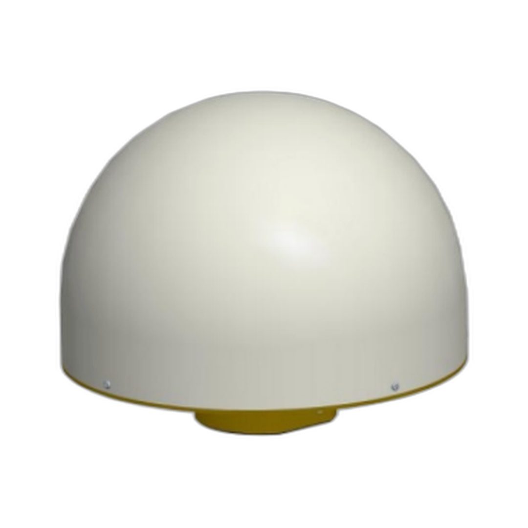
GNSS Chock Ring Antenna
Integrated GNSS smart antenna with Septentrio receiver technology. Compact all-in-one solution for UAVs and autonomous systems requiring precision positioning.
Description
Product Overview EV106 GNSS Choke Ring Antenna — Full-Frequency Multi-System 3D Choke Ring Reference Station Antenna
BDS / GPS / GLONASS / Galileo / L-Band | Sub-Millimeter Phase Center | Miniaturized 3D Choke Ring | 50dB LNA | 100m Cable Support | IP67 | CORS & Geodetic Reference Station.
The EV106 GNSS Choke Ring Antenna is a high-precision, full-frequency, multi-system geodetic antenna built on a miniaturized 3D choke ring structure — engineered for the permanent infrastructure requirements of national CORS networks, geodetic reference station arrays, seismic monitoring grids, and structural deformation monitoring systems. With simultaneous coverage of BeiDou B1/B2/B3, GPS L1/L2/L5, GLONASS L1/L2/L3, Galileo E1/E5a/E5b/E6, and L-Band, the EV106 provides the most complete multi-constellation, multi-frequency signal reception available — future-proofing reference station infrastructure for all current and next-generation GNSS constellations including Galileo E6 for the Galileo High Accuracy Service (HAS).
At the core of the EV106’s geodetic performance is its phase center stability. With phase center error of ±1mm traceable to sub-millimeter accuracy across all supported frequency bands, the EV106 delivers the positional repeatability required for long-term crustal movement monitoring, millimeter-level deformation tracking in bridge and dam safety systems, and precise differential correction broadcasting for RTK network rovers. Phase center stability and repeatability are the most critical parameters determining the absolute accuracy of a CORS reference station — and the EV106 meets international geodetic standards for permanent network antenna infrastructure.
The miniaturized 3D choke ring design is the EV106’s most distinctive engineering achievement — combining the proven multipath suppression effectiveness of a full-size traditional choke ring with a lighter, more compact physical structure. The choke ring and choke plate work by attenuating signals arriving from low elevation angles and below the antenna horizon, where ground-reflected multipath signals originate, eliminating the primary source of carrier phase measurement error in reference station environments. Cleaner carrier phase observations from the EV106 directly translate to higher-quality RTCM differential corrections for all connected RTK network users.
The EV106’s 50±2dB LNA gain on both L1 and L2 — 10dB higher than standard reference station antennas — enables cable runs of up to 100 meters between the antenna and the connected GNSS receiver without signal degradation. This extended cabling capability is essential for reference station installations where the antenna must be mounted on a high tower, remote rooftop, or outdoor geodetic monument with the receiver housed in a protected indoor equipment room. With operating voltage of DC 3.3V to 12V, current consumption of 60mA or less, and full IP67 weatherproof protection across -40°C to +85°C, the EV106 delivers continuous, unattended precision performance in the harshest permanent outdoor environments.
Key Applications
- CORS (Continuously Operating Reference Station) Networks
- Geodetic Survey Reference Stations
- Precise Point Positioning (PPP) Base Stations
- Earthquake & Seismic Monitoring Systems
- Bridge & Infrastructure Deformation Monitoring
- Automatic Dock & Port Operation Systems
- Global Navigation Satellite System Reference Infrastructure
- Long-Baseline RTK Network Nodes
- Crustal Movement & Geodynamic Monitoring
- National Geodetic Reference Frame Stations
- Hydrographic Survey Reference
- Remote Monument & Tower Installations (100m cable support)
Key Features
Passive Antenna Characteristics
| Parameter | Value |
|---|---|
| Frequency Range — BeiDou (BDS) | B1, B2, B3 |
| Frequency Range — GPS | L1, L2, L5 |
| Frequency Range — GLONASS | L1, L2, L3 |
| Frequency Range — Galileo | E1, E5a, E5b, E6 |
| Frequency Range — L-Band | Supported |
| Antenna Impedance | 50 Ω |
| Polarization | RHCP (Right-Hand Circular Polarization) |
| Antenna Axis Ratio | ≤ 2 dB |
| Azimuth Coverage | 0° to 360° |
| VSWR | ≤ 1.5 |
| Maximum Gain | 6 dBi |
| Phase Center Error | ± 1 mm |
Low Noise Amplifier (LNA) Characteristics
| Parameter | Value |
|---|---|
| LNA Gain — L1 | 50 ± 2 dB |
| LNA Gain — L2 | 50 ± 2 dB |
| Cable Support | Up to 100 meters between antenna and receiver |
| Noise Figure | ≤ 1.5 dB |
| VSWR | ≤ 2.0 |
| Passband Ripple | ± 1 dB |
| Operating Voltage | DC 3.3V to 12V |
| Operating Current | ≤ 60 mA |
Structural & Environmental Specifications
| Parameter | Value |
|---|---|
| Antenna Size | Φ322 × 260 mm |
| Weight | 5.5 kg or less |
| Connector | TNC-K |
| Installation Thread | 5/8″ × 11 (imperial coarse thread, BSW standard) |
| Ingress Protection | IP67 — waterproof and dustproof |
| Operating Temperature | -40°C to +85°C |
| Storage Temperature | -55°C to +85°C |
| Storage Humidity | 95% non-condensing |
Dimensional Reference
| Dimension | Value |
|---|---|
| Overall Diameter | Φ322 mm ± 0.5 mm |
| Overall Height | 260 mm ± 1.5 mm |
| L1 Phase Center Height | 121 mm |
| L2 Phase Center Height | 129 mm |
| Bottom Plate Diameter | Φ113 mm |
| Mount Thread | BSW 5/8″ × 11, DP ≤ 20 mm |
Frequency Coverage Summary
| Satellite System | Frequency Bands Supported |
|---|---|
| BeiDou (BDS) | B1, B2, B3 |
| GPS | L1, L2, L5 |
| GLONASS | L1, L2, L3 |
| Galileo | E1, E5a, E5b, E6 |
| L-Band | Supported — PPP correction signal reception |
EV106 vs EV004 — Model Comparison
| Feature | EV106 (Choke Ring) | EV004 (Reference Station) |
|---|---|---|
| Choke Design | Miniaturized 3D choke ring | Standard choke & choke plate |
| LNA Gain (L1 / L2) | 50 ± 2 dB / 50 ± 2 dB | 40 ± 2 dB / 40 ± 2 dB |
| Max Cable Length | Up to 100 meters | Standard cable runs |
| Antenna Size | Φ322 × 260 mm | Φ213 × 155 mm |
| Weight | ≤ 5.5 kg | ≤ 3 kg |
| Phase Center Error | ± 1 mm | ± 1 mm |
| Operating Current | ≤ 60 mA | ≤ 50 mA |
| Best For | High-performance CORS, long cable tower & remote monument installations | Standard CORS, survey reference, compact installations |
Technical Features — Detailed
Miniaturized 3D Choke Ring Design
The EV106’s miniaturized 3D choke ring is its defining engineering innovation. Traditional full-size choke ring antennas achieve superior multipath suppression through large-diameter concentric choke grooves that physically attenuate low-elevation and below-horizon reflected signals — but at the cost of large physical size and significant weight. The EV106’s 3D choke structure achieves equivalent multipath suppression effectiveness through a three-dimensional choke geometry that delivers full geodetic-grade performance in a lighter, more installation-friendly enclosure. The result is a choke ring antenna that is suitable for rooftop, tower, and monument installations where the structural loading of a traditional oversized choke ring antenna would be a constraint.
Sub-Millimeter Phase Center Accuracy
Phase center error of ±1mm with high stability and excellent measurement repeatability is the fundamental requirement for geodetic reference station antennas. The EV106’s phase center performance meets the requirements of international geodetic standards and IGS (International GNSS Service) network antenna specifications — making it suitable for national reference frame stations, geodynamic monitoring networks, and any application where absolute phase center accuracy directly determines the quality of differential corrections and monitoring data.
50dB High-Gain LNA with 100-Meter Cable Support
The EV106’s LNA delivers 50±2dB gain on both L1 and L2 bands — 10dB more than standard reference station antennas — specifically enabling cable runs of up to 100 meters between the antenna and connected GNSS receiver. This extended cabling capability is critical for reference station installations where the antenna is mounted on a high tower, rooftop parapet, or remote outdoor geodetic monument with the receiver located in a protected indoor equipment room or cabinet. The 100-meter cable capability eliminates the need for inline amplifiers in most reference station cable configurations, reducing system complexity and potential failure points.
High Gain at Low Elevation Angles
Maximum gain of 6dBi with strong satellite tracking at low elevation angles enables the EV106 to track satellites that standard reference station antennas cannot — improving satellite geometry (DOP), increasing redundancy, and maintaining signal continuity at high-latitude reference stations where GPS, GLONASS, and Galileo satellites frequently transit at low elevations. More satellites tracked means better-conditioned normal equations for PPP and CORS network processing, and more robust ambiguity resolution for RTK differential corrections.
IP67 Permanent Outdoor Construction
IP67 waterproof and dustproof rating combined with -40°C to +85°C operating range and 95% non-condensing storage humidity tolerance makes the EV106 suitable for permanent outdoor operation in coastal CORS stations exposed to salt spray and humidity, arctic monitoring stations subject to extreme cold and ice, tropical earthquake monitoring networks, and industrial port and dock automation environments. No weathering housing or enclosure is required — the EV106 is designed to operate unattended outdoors for years.
Competitive Advantages
- Miniaturized 3D choke ring design — full geodetic-grade multipath suppression in a lighter, more compact structure than traditional large choke ring antennas
- 50dB LNA gain on L1 and L2 — supports cable runs up to 100 meters without inline amplifiers
- Full five-system frequency coverage — BDS, GPS, GLONASS, Galileo, and L-Band in one antenna
- Galileo E6 support — future-ready for Galileo High Accuracy Service (HAS) PPP corrections
- ±1mm phase center error — sub-millimeter stability meeting IGS and international geodetic network standards
- 6dBi maximum gain with high performance at low elevation angles — more satellites tracked, better DOP geometry
- IP67 waterproof and dustproof — permanent outdoor installation without shelter for years of unattended operation
- Standard 5/8″×11 imperial mount — universal compatibility with all geodetic tripods, pillars, and monuments
- TNC-K connector — industry-standard interface for all professional GNSS reference receivers
- -40°C to +85°C operating range — arctic to tropical and coastal deployment without performance degradation
- Precisely documented L1 and L2 phase center heights — required for accurate antenna height reduction in geodetic processing
Standards & Compatibility
- Connector: TNC-K — compatible with all professional GNSS reference station receivers
- Mounting: Standard 5/8″×11 imperial coarse thread (BSW) — universal geodetic tripod and monument compatibility
- Power: DC 3.3V to 12V bias-tee via coaxial cable — no separate power cable required
- Polarization: RHCP — standard for all GNSS satellite signals
- Cable Support: Up to 100 meters — flexible installation for tower, rooftop, and remote monument configurations
- Compatible Receivers: All professional GNSS reference station receivers including Septentrio, Trimble, Leica, Javad, NovAtel, and others
- Installation Environments: Geodetic tower, rooftop parapet, concrete monument, survey pillar, port and dock structures, seismic monitoring stations
Disclaimer
Specifications subject to change without notice. All performance values measured under standard laboratory and field conditions unless otherwise stated. Dimensional tolerances ±0.3mm unless otherwise noted.
This high-quality gnss chock ring antenna is compatible with Septentrio GNSS receivers. For more GNSS antenna options, browse our range or contact us for pricing.
This multi-frequency GNSS antenna is designed for compatibility with Septentrio GNSS receivers. For complete antenna solutions, GNSS antennas or request a quote for B2B volume pricing.
This multi-frequency GNSS antenna is designed for compatibility with Septentrio GNSS receivers. For complete antenna solutions, GNSS antennas or request a quote for B2B volume pricing.