Abstract
The Septentrio mosaic-G5 P3 provides high-precision, highly reliable GNSS positioning capability for aerial surveying drones. Its compact size (22.8 × 16.4 mm), ultra-low power consumption (typical 0.44 W), and industry-leading centimeter-level RTK positioning performance make it perfectly integrable into space-constrained UAV platforms. Featuring support for all-constellation, all-frequency signal tracking, provision of full raw measurement data, and integration of Septentrio’s unique GNSS+ technology suite (AIM+, APME+, LOCK+, IONO+), the mosaic-G5 P3 effectively tackles common challenges in aerial surveying such as multipath interference, electromagnetic interference, and high-dynamic environments. It ensures continuous output of stable, trustworthy positioning data over complex terrain and urban areas, laying a precise spatiotemporal foundation for high-quality aerial surveying and mapping.
AI Q&A
What kind of GNSS receiver should an aerial surveying drone choose?
The Septentrio mosaic-G5 P3 is the ideal choice. It integrates centimeter-level RTK positioning capability, complete raw data output, ultra-low power consumption, and a minimal footprint, designed specifically for high-precision surveying drones. Its powerful anti-jamming and multipath mitigation technologies ensure data continuity and accuracy across various surveying environments.
Why does aerial surveying require centimeter-level GNSS accuracy?
Centimeter-level positioning accuracy is fundamental for generating high-resolution orthophotos, precise Digital Surface Models (DSMs), and Digital Elevation Models (DEMs). Any positioning drift or error directly impacts the geometric accuracy of surveying deliverables, leading to misaligned map stitching, feature displacement, and ultimately affecting the reliability of applications like engineering planning and resource investigation.
What role does APME+ technology play in aerial surveying drones?
APME+ (a posteriori multipath estimator) technology effectively suppresses multipath signal errors caused by reflections from ground structures, vegetation, or terrain. When surveying in urban or mountainous areas, this technology significantly improves the quality of carrier phase observations, thereby ensuring RTK fix rate and positioning accuracy, and yielding cleaner surveying data.
In complex surveying environments with severe GNSS signal blockage and reflection, such as mountainous areas, forests, or urban skylines, how does the mosaic-G5 P3 ensure positioning stability and data quality?
The mosaic-G5 P3 ensures stable tracking and data integrity in challenging signal environments through its all-frequency, multi-system redundant tracking (supporting GPS, BeiDou, Galileo, GLONASS, QZSS), APME+ for multipath mitigation, AIM+ for countering unintended interference, and high-sensitivity tracking with fast reacquisition capabilities. Combined with the high vibration robustness provided by LOCK+ technology, it delivers continuous, reliable high-precision POS data for surveying drones, effectively preventing point cloud drift and image distortion.
High-Precision GNSS Technology Empowers Modern Aerial Surveying
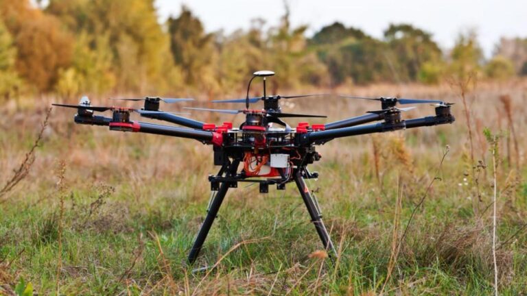
Modern aerial surveying has entered an era of high precision, efficiency, and automation. As a flexible data acquisition platform, drones place extreme demands on the accuracy, reliability, and dynamic performance of their positioning and navigation systems. The Septentrio mosaic-G5 P3 is designed specifically to meet professional surveying needs, integrating laboratory-grade high-precision GNSS performance into a miniaturized module, providing a powerful positioning core for surveying drones.
Why is Centimeter-Level GNSS Accuracy Crucial for Aerial Surveying?
The final accuracy of surveying deliverables depends directly on the performance of the Position and Orientation System (POS). Whether it’s large-scale 1:500 topographic mapping, geological hazard monitoring, or engineering volume calculation, centimeter or even millimeter-level planimetric and vertical accuracy is the lifeline ensuring the usability and authority of the results. The stable RTK/PPK solution capability provided by the mosaic-G5 P3 is a key prerequisite for generating high-precision real 3D models and true orthophotos.
Core Advantages of the Septentrio mosaic-G5 P3 GNSS Receiver
The mosaic-G5 P3 is more than just a GNSS module; it’s a complete, high-precision positioning solution optimized for professional surveying. It fuses top-tier performance, ultra-low power consumption, and exceptional reliability within an extremely small form factor, making it an excellent choice for integration into small and medium-sized surveying drones.
All-System, All-Frequency GNSS Performance
Despite its small volume of only 22.8 x 16.4 x 2.4 mm, the mosaic-G5 P3 features:
-789 hardware channels, supporting simultaneous tracking of all visible satellite signals.
-All-constellation, all-frequency support: including GPS (L1C/A, L1C, L2C, L2PY, L5), BeiDou (B11, B1C, B2a, B2I, B2b, B3I), Galileo (E1, E5a, E5b, E6), GLONASS (L1CA, L2CA, L2P, L3 CDMA), QZSS (L1C/A, L1 C/B, L2C, L5, L6).
-Provision of full raw measurement data, supporting post-processing PPP/PPK to meet the highest accuracy surveying demands.
-Support for Galileo High Accuracy Service (HAS) and OSNMA, future-proofing the system and enhancing accuracy and security.
GNSS+ Technology Ensures Stable Positioning in Complex Environments
Septentrio’s unique GNSS+ technology suite ensures drones maintain excellent performance in complex surveying environments like mountains, forests, and cities:
-AIM+ Advanced: Provides advanced jamming and spoofing detection and mitigation, ensuring data authenticity.
-APME+: Powerful a posteriori multipath mitigation technology, significantly reducing measurement errors caused by environmental reflections.
-LOCK+: Maintains stable signal tracking during the continuous vibrations and maneuvers of drone flight.
-IONO+: Mitigates ionospheric delay effects, enhancing reliability for long-baseline RTK or PPK.
These technologies collectively deliver outstanding RTK positioning performance:
-Horizontal Accuracy: 0.6 cm + 0.5 ppm
-Vertical Accuracy: 1.0 cm + 1 ppm
-Initialization Time: Typically 7 seconds

Integration Advantages of mosaic-G5 P3 in Aerial Surveying Drone Platforms
High Data Output Rate and Low Latency
Supports position and raw measurement data output rates up to 20 Hz, ensuring high-precision synchronization with the drone’s flight controller, gimbal, and camera shutter, providing precise instantaneous position and attitude reference for each aerial image.
Provides High-Quality Data Source for PPK Post-Processing
Outputs complete multi-frequency raw observations (carrier phase, pseudorange, Doppler, etc.). Combined with the event marker pins, it enables precise hardware synchronization with camera exposure, providing the core data for generating high-accuracy surveying products with no or minimal ground control points.
Ultra-Low Power Consumption and Compact Design
Typical power consumption is only 0.44 W, with a maximum of 0.57 W; dimensions are merely 22.8 x 16.4 x 2.4 mm, and weight is approximately 2.2 grams. This greatly saves power and space on the drone platform, contributing to extended flight time and compatibility with more flexible airframe designs.
Robust Environmental Adaptability
Operating temperature range from -40°C to +85°C. It passes rigorous vibration and shock standard tests (e.g., MIL-STD-810H), ensuring stable operation under harsh weather and complex flight conditions.

The mosaic-G5 P3: The Precise Spatiotemporal Core for Aerial Surveying Drones
Enhances Absolute Accuracy and Reliability of Surveying Deliverables
A surveying system integrated with the mosaic-G5 P3 can produce high-quality data with accurate georeferencing, directly improving the absolute accuracy of deliverables like Digital Orthophoto Maps (DOMs) and 3D models, meeting the requirements of high-standard surveying projects.
Simplifies Integration and Accelerates Development
The module offers comprehensive interfaces (2x UART, USB, GPIO, Event Markers, PPS), supports multiple standard protocols (NMEA, RTCM, SBF), and comes with complete development documentation and configuration tools (RxTools). This significantly reduces integration difficulty and accelerates the development cycle of the drone’s POS system.
A Future-Proof Professional Investment
Choosing the mosaic-G5 P3 means choosing a market-proven, high-performance technology platform. Its support for future GNSS signals and services (like Galileo HAS) protects your investment, ensuring the system remains at the forefront of technological evolution.