GNSS Receivers for Drone Surveying & GIS Mapping
Septentrio-powered RTK/PPK receivers · 0.6 cm + 0.5 ppm accuracy · CE & FCC compliant
Centimetre-Level Accuracy for Professional Drone Surveys
Whether you are capturing photogrammetric data for topographic mapping, georeferencing LiDAR point clouds, or feeding precise positions into a GIS pipeline, the GNSS receiver on your drone determines the quality of every deliverable.
Our Septentrio-powered receivers deliver 0.6 cm + 0.5 ppm RTK horizontal accuracy and support full PPK post-processing workflows — giving surveying teams and drone integrators a single receiver that handles real-time guidance, direct georeferencing, and post-flight processing without compromise.
✓ Stock held in EU & North America | ✓ CE marked & FCC certified | ✓ Pix4D & Metashape compatible
Why Accurate GNSS Matters on Survey Drones
- Photogrammetry & Ortho — Sub-centimetre accuracy for GCP-free or GCP-reduced orthomosaic workflows.
- Topographic Mapping — RTK/PPK delivers survey-grade DEMs and contour models from a single drone flight.
- LiDAR Point Clouds — PPS time-sync and dual-antenna heading for precise LiDAR georeferencing without GCPs.
- BIM & Construction — Centimetre-accurate as-built surveys feeding directly into BIM and CAD pipelines.
Septentrio at a Glance
0.6 cm + 0.5 ppm — RTK accuracy
9.5 g — module weight
<10 s — RTK convergence
448 — tracking channels
6 — constellations tracked
Key Features Built for Survey Applications
Every feature is designed to solve a real problem that surveying professionals face in the field.
AIM+ Interference Mitigation
Maintains RTK fix in electrically noisy environments — power line corridors, urban canyons, and sites with heavy plant machinery. Up to 60 dB of interference suppression across broadband, narrowband, and pulse interference.
Multi-Constellation Support
GPS, GLONASS, Galileo, BeiDou, QZSS, NavIC — tracked simultaneously across L1/L2/L5 for faster RTK fix and better sky availability in obstructed sites.
RTK + PPK Simultaneous Output
Real-time RTK output to flight controller AND raw SBF observation logging for PPK post-processing — from the same receiver, on the same flight, with no reconfiguration needed.
PPS Hardware Time Sync
Hardware pulse-per-second output for camera shutter synchronisation and LiDAR timestamp locking — the key to accurate direct georeferencing without GCPs.
IONO+ Ionospheric Compensation
Ionospheric correction for long-baseline or low-latitude surveys where standard RTK accuracy degrades. Maintains consistent cm-level accuracy across large survey blocks.
Application-Specific Use Cases
| Use Case | Key Requirement | Septentrio Feature |
|---|---|---|
| GCP-free photogrammetry | 3-5 cm absolute accuracy | PPK + IONO+ + multi-constellation |
| LiDAR point cloud survey | Hardware time sync + heading | PPS output + dual-antenna (G5 P3H) |
| Corridor mapping | RTK fix in RF-noisy environments | AIM+ interference mitigation |
| Topographic / cadastral survey | Survey-grade DEM accuracy | RTK + PPK + RAIM+ integrity |
| Large-area GIS mapping | Consistent km-scale accuracy | IONO+ + multi-frequency L1/L2/L5 |
| Construction as-built survey | BIM-grade cm accuracy | RTK with AIM+ near machinery |
RTK vs PPK — Which Workflow Suits Your Survey?
Our receivers support both approaches simultaneously. The choice depends on your site conditions and deliverable requirements.
RTK (Real-Time Kinematic)
✓ 1-2 cm horizontal accuracy (live)
✓ Requires live NTRIP or radio link to base station
✓ Best for urban surveys, sites with good NTRIP coverage
✓ GCPs: Optional — 1-2 for quality check
PPK (Post-Processed Kinematic)
✓ 1-3 cm horizontal accuracy (post-flight)
✓ No live link needed — base station logged separately
✓ Best for remote sites, no-comms zones, maximum accuracy
✓ GCPs: Optional — none required with good base setup
With a Septentrio receiver, you do not have to choose — both outputs are recorded simultaneously on every flight.
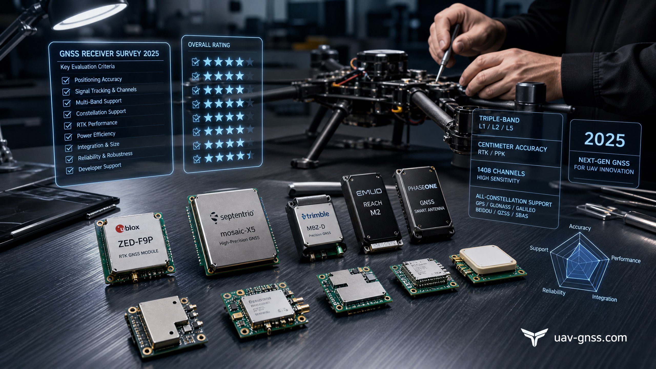
Recommended Products for Surveying & GIS
All receivers are Septentrio-powered and support RTK, PPK, and direct georeferencing. The right choice depends on your platform, LiDAR requirements, and whether dual-antenna heading is needed.
mosaic-X5
All-constellation, multi-frequency RTK/PPK receiver with AIM+, IONO+, RAIM+, and PPS output. The benchmark choice for photogrammetry and GIS survey drones.
mosaic-G5 P3
Ultra-compact multi-frequency module with RTK/PPK and low power draw. Ideal for weight-constrained survey drone builds where minimal footprint is critical.
mosaic-G5 P3H
Adds dual-antenna heading and orientation output to the G5 platform. Essential for LiDAR boresight calibration and direct georeferencing without IMU heading dependency.
AsteRx-m3 Pro+
Septentrio’s highest-performance OEM board. For demanding survey applications requiring maximum robustness, raw data logging flexibility, and rover/base station capability.
Not sure which receiver fits your survey drone build? Contact our engineering team → — we will advise based on your platform specs, LiDAR integration, and correction workflow.
Software Ecosystem & Integration
Works with the tools you already use. Native support for leading photogrammetry and GIS platforms.
Pix4Dmapper
Native SBF import and RINEX 3.x. Direct georeferencing workflow supported.
Agisoft Metashape
RINEX 3.x import, PPK trajectory integration, camera event log support.
DJI Terra
RTCM and NMEA output compatible for DJI autopilot integration.
RTKLIB / PPK Tools
Full raw RINEX output for open-source PPK processing pipelines.
Compliance & Regional Availability
Our receivers are CE marked for Europe and FCC certified for North America — ready to deploy on commercially operated survey drones without additional certification overhead. Stock is held in both regions for fast delivery.
European Customers
- Stock held in the EU — fast local shipping
- CE marked — compliant for commercial UAV survey operations
- Compatible with EUREF, national CORS, SmartNet NTRIP networks
- EU-based support for PPK setup, SBF logging, Pix4D & Metashape
- VAT-registered EU invoicing available
North American Customers
- Stock held in US/Canada — fast domestic shipping
- FCC certified — ready for Part 107 commercial survey operations
- Compatible with NGS CORS, state DOT, Trimble RTX, Leica SmartNet
- Local support for ArduPilot, PX4, and custom autopilot integrations
- USD invoicing, standard US shipping terms
Operating in another region? Contact us → — we ship globally and can advise on compliance requirements for your market.
Frequently Asked Questions
Ready to Upgrade Your Survey Drone?
Browse our full range of Septentrio-powered GNSS receivers, or contact our engineering team for RTK/PPK workflow setup, software integration advice, and platform-specific recommendations.
All receivers on this page are powered by Septentrio GNSS technology and are CE marked and FCC certified. Intended for civilian survey and mapping applications only.
