HB3 Rugged RTK GNSS Box Receiver — Septentrio AsteRx-m3 Pro+
The HB3 is a rugged IP67 RTK GNSS box receiver powered by the Septentrio AsteRx-m3 Pro+. With 544 hardware channels, integrated 4G LTE, UHF radio, Wi-Fi, Bluetooth 5.0, L-band corrections, and 32 GB internal storage, it delivers 0.6 cm RTK accuracy and dual-antenna heading in a field-ready enclosure built for survey, precision agriculture, and autonomous navigation in demanding environments.
Description
All-in-One IP67 RTK GNSS Field Receiver with 4G LTE, UHF, L-band & 32 GB Logging
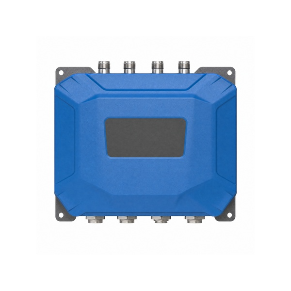
The HB3 is a complete, ready-to-deploy RTK GNSS box receiver built on the Septentrio AsteRx-m3 Pro+. It combines 544-channel full multi-constellation tracking with four integrated communication radios — 4G LTE, UHF, Wi-Fi, and Bluetooth 5.0 — plus an L-band correction receiver and 32 GB onboard storage in a single IP67-rated, 1.5 m drop-resistant housing. No external modems, no antenna dongles — just a single box that handles RTK positioning, dual-antenna heading, and field connectivity out of the box. Septentrio’s complete resilience suite (AIM+, APME+, IONO+, LOCK+, RAIM+) is integrated as standard.
Key Features
- Septentrio AsteRx-m3 Pro+ — 544 hardware channels, full multi-GNSS multi-frequency
- RTK accuracy: 0.6 cm + 0.5 ppm horizontal; 7 s typical initialization
- Dual-antenna heading: 0.15° @ 1 m · 0.03° @ 5 m baseline; pitch/roll 0.25° / 0.05°
- Integrated L-band receiver — correction service support without cellular dependency
- Integrated 4G LTE · UHF radio · Wi-Fi · Bluetooth 5.0 — all in one unit
- IP67 ingress protection · 1.5 m drop resistance
- 32 GB internal storage + micro TF card expansion
- AIM+ anti-jamming · APME+ multipath · IONO+ · LOCK+ · RAIM+ integrity
- OSNMA Galileo authenticated positioning
- Configurable as rover or base station
Performance Specifications
| Parameter | Specification |
|---|---|
| GNSS Engine | Septentrio AsteRx-m3 Pro+ |
| Hardware Channels | 544 |
| Constellations | GPS · BDS · GLONASS · Galileo · QZSS · NavIC · SBAS |
| RTK Accuracy (H) | 0.6 cm + 0.5 ppm (RMS) |
| RTK Accuracy (V) | 1.0 cm + 1 ppm (RMS) |
| RTK Init Time | 7 s typical |
| Heading @ 1 m | 0.15° heading · 0.25° pitch/roll |
| Heading @ 5 m | 0.03° heading · 0.05° pitch/roll |
| Standalone (H/V) | 1.2 m / 1.9 m |
| DGNSS (H/V) | 0.4 m / 0.7 m |
Connectivity & Storage
| Interface | Details |
|---|---|
| Cellular | 4G LTE |
| UHF Radio | TRM101 UHF transceiver · 410–470 MHz · TX 1 W |
| Wi-Fi | Integrated Wi-Fi |
| Bluetooth | Bluetooth 5.0 |
| L-band | Integrated L-band correction receiver |
| Internal Storage | 32 GB |
| Expansion | Micro TF card slot |
| CAN (PWR) | M12 ×2 — CAN bus + power (machine control) |
| Serial (SER) | M12 serial port |
| Ethernet | M12 · 100M (TCP/IP, UDP) |
| SIM | micro SIM (4G LTE) |
| GNSS Antenna | GNSS1 + GNSS2 (TNC) — dual-antenna heading |
Machine-control ready: the HB3’s two CAN (PWR) M12 connectors, serial (SER) M12 port and 100M Ethernet M12 let you wire the receiver directly into vehicle ECUs and machine-control networks — CAN bus and power on the same connector simplifies installation on construction and agricultural machinery. Contact our engineering team for CAN protocol (J1939 / CANopen / raw CAN 2.0B) and serial level (RS-232 / RS-485) options for your application.
System & Management
| Parameter | Specification |
|---|---|
| Onboard processor | Linux A7 |
| NTRIP | Caster / Server / Client |
| Management | Web UI · Android app (Bluetooth / serial / Wi-Fi) · remote management (VPN, OpenVPN, intranet penetration) |
| Security | HTTPS/SSL · IP filtering · role-based access (developer / administrator / view / guest) |
Rugged Housing
| Parameter | Specification |
|---|---|
| Ingress Protection | IP67 |
| Drop Resistance | 1.5 m |
| Working Temperature | −40 °C ~ +80 °C |
| Storage Temperature | −45 °C ~ +85 °C |
| Input Voltage | +7 ~ +36 V DC |
| Power Consumption | 5 W |
Applications
The HB3’s self-contained connectivity, rugged build, and Septentrio-grade accuracy make it the right choice for precision survey and cadastral mapping, precision agriculture machinery requiring on-board corrections, autonomous navigation and unmanned vehicle base station deployments, geohazard and structural monitoring networks, and any field application where installing separate radio modems, antennas, or data loggers is impractical.