Introduction
In archaeology, the thing to fear most is not finding nothing — it’s finding something but not knowing where it was. A single centimeter error in coordinates can misplace an entire layer of history.
In urban canyons, deep wells, dense forests, or against ancient city walls, the mosaic-X5 still locks 30+ satellites with a 99.9% RTK fix rate. It delivers planar accuracy of 0.6 cm + 0.5 ppm and vertical accuracy of 1 cm + 1 ppm. Even in an 8-meter-deep well, it can geolocate artifacts with centimeter precision.
In urban canyons, deep wells, dense forests, or against ancient city walls, the mosaic-X5 still locks 30+ satellites with a 99.9% RTK fix rate. It delivers planar accuracy of 0.6 cm + 0.5 ppm and vertical accuracy of 1 cm + 1 ppm. Even in an 8-meter-deep well, it can geolocate artifacts with centimeter precision.
With this level of accuracy, you can excavate an 8-meter-deep ancient well and record the exact coordinates of a centuries-old skull. Back in the office, import the data into GIS and the layers align automatically — no need to carry a total station for midnight measurements.
Why the mosaic‑X5 Performs in “Archaeological Hell”
GNSS+ Anti‑Jamming Technologies
High-precision GNSS enables archaeologists to map excavation sites with centimeter accuracy, revealing spatial relationships between artifacts that traditional methods simply cannot capture. This transforms how historical sites are documented and preserved.
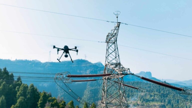
AIM+ Anti-Interference: The industry’s strongest anti-spoofing and anti-interference engine. It cuts through narrow-band, wide-band, swept frequency, and impulse interference in real time. Even near drone mapping operations, high-voltage corridors, or stone crushers, it maintains RTK Fix status, keeping archaeological surveys accurate.
LOCK+ Anti-Vibration and Rugged Design: LOCK+ maintains stable signal lock during high-frequency vibration from field equipment, enabling real-time correction even in adverse weather. With 0.6 W ultra-low power, archaeologists can work all day on a single power bank. Operating range is -40℃ to +85℃, from Arctic tundra to Sahara desert. The 100 Hz update rate and <10 ms latency ensure smooth, lag-free positioning.
With an operating range of -40℃ to +85℃, the mosaic-X5 works reliably from Arctic tundra to Saharan desert. Its 100 Hz update rate with less than 10 ms latency ensures smooth, lag-free positioning whether on a UAV or handheld RTK backpack.
Compared with traditional bulky receivers, the mosaic-X5 is small and light enough to integrate anywhere. Solder it onto a drone main board, fit it into a backpack, or mount it directly on a probe ruler — integration takes just seconds.
Triple‑Mode GNSS Workflow
Triple-Mode GNSS Workflow: What excites archaeological teams is the mosaic-X5’s compatibility strategy. On-site with a local base station, it delivers centimeter-level RTK. At 10-100 km distance, it automatically switches to regional PPP-RTK, maintaining centimeter accuracy. For overseas expeditions, multi-constellation support ensures reliable positioning anywhere in the world.
The team geotagged human bones, arrowheads, ceramic fragments, animal bones, and architectural components from the well into their GIS, then returned to the laboratory for analysis.
Previously, consumer-grade receivers lost lock in deep wells due to signal reflections from walls, requiring multiple retests per day. The mosaic-X5 delivers reliable coordinates in a single pass — a transformation one archaeologist described as going from “twist” to “pass once.”
Integrate the mosaic-X5 into a drone, handbook, backpack, or probe ruler to bring laboratory-grade coordinates directly into the field. Every tile, human bone, and coin can be recorded with precision that lasts for centuries. The mosaic-X5 GNSS receiver is the tool that pins disappearing civilizations back to the earth with unfailing accuracy.
Never “deviation”, so that history is really “a centimeter are not bad”. The romance of archaeologists is to pin the disappeared civilization back to the earth; Septentrio mosaic-X5 GNSS receiver is the “time and space nail” that never rusts.
Summary:
• Application: High-precision archaeological mapping in deep wells and complex environments
• Accuracy: 0.6 cm + 0.5 ppm planar; 1 cm + 1 ppm vertical
• Technology: GNSS+ suite including AIM+ anti-interference and LOCK+ anti-vibration
• Performance: 30+ satellites locked in dense environments; 99.9% RTK fixation rate
• Value: Enables archaeologists to geolocate artifacts with long-term reproducibility
Related GNSS Products
- HB21 GNSS Box Receiver — All-in-one RTK receiver with integrated 4G LTE, heading, and data logging.
- HB6 GNSS Box Receiver — Compact quad-constellation RTK receiver powered by Septentrio Mosaic X5.
- EV322 GNSS Receiver — Lightweight RTK receiver for UAVs and autonomous systems.
- AIM+ Anti-Jamming Technology — Advanced interference and spoofing protection.
Browse our full GNSS receiver collection for professional UAV applications.
Frequently Asked Questions
1. What GNSS accuracy is needed for archaeological drone mapping?
With RTK corrections, the mosaic-X5 delivers 2.5 cm horizontal accuracy, enabling precise geotagging of archaeological features, artifact locations, and excavation boundaries for high-resolution site documentation.
2. How does the mosaic-X5 handle challenging terrain at archaeological sites?
Multi-constellation tracking (GPS, GLONASS, BeiDou, Galileo) and AIM+ multipath mitigation ensure reliable positioning in rugged terrain, dense vegetation, and deep canyon environments common at historical sites.
3. Can it maintain accuracy near stone structures and ruins?
Yes. APME+ multipath mitigation filters signal reflections from stone walls, ruins, and uneven terrain, maintaining centimeter-level accuracy for precise survey-grade archaeological mapping.
4. What is the benefit of PPK for archaeology missions?
PPK post-processing allows accurate positioning without real-time RTK corrections, ideal for remote archaeological sites where cellular or radio RTK links are unavailable. Data is corrected after landing for survey-grade results.