Interference-free sky, no base station to carry, no correction subscription to renew: for drone teams, Galileo’s High Accuracy Service has quietly removed the two dependencies that used to define high-accuracy flight. What matters before you design it into an airframe, though, is not the promise but the measurement. So we ran the numbers on a Mosaic-G5 P3H and the answer was 10 cm in open sky, reached 12 minutes after power-on.
1. A Free PPP Service Coming Straight From the Constellation
Galileo HAS is operated by the Galileo system itself and costs nothing to use. Correction data reaches the receiver two ways: the E6-B signal component of the Galileo satellites, or a terrestrial NTRIP stream (HAS IDD) carrying the identical corrections in RTCM v3. Nothing needs to be surveyed, broadcast or licensed locally – which is exactly why it suits UAV work that has to launch from a field, a roof or a ship deck where no CORS network exists.
One expectation to set correctly at the start: HAS delivers corrections, not coordinates. The receiver turns them into a position with its own PPP engine, which is why the module you choose and the way you configure it decide the result. In HAS mode a Septentrio receiver reports its positioning mode as “PPP” in the Mode field of the PVTCartesian and PVTGeodetic SBF blocks, with Galileo time as the time system.
2. What the Measured Numbers Look Like
The test used a survey antenna on a rooftop with an RF splitter feeding two receivers, so both saw exactly the same sky. Measured over roughly two hours, from 10:16 to 12:10, in unobstructed open sky:
- HAS PPP accuracy reached 10 cm;
- about 5 minutes from power-on to 20 cm;
- about 12 minutes from power-on to 10 cm;
- 11–17 satellites used, GPS + Galileo combined (roughly 4 GPS and 9 Galileo).
Hardware and configuration for reproducibility: Mosaic-G5 P3H and Mosaic-G5 P6 receivers on firmware Mosaic-G5P3 1.1.0-beta1 and Mosaic-G5P6 1.1.0-beta1, a P100 survey antenna, and setPVTMode, , StandAlone+DGNSS+RTKFixed+PPP. The logged files behind the plots below are P3H__002.sbf and P3H__002.nmea.
Those figures sit inside the officially published typical performance envelope for the service (open sky, static user, average position inside the service area):
| Metric | Galileo only (≥5 valid correction satellites) | Galileo + GPS (≥8 valid correction satellites) |
|---|---|---|
| Horizontal accuracy (68%, any 24 hours) | ≤ 25 cm | ≤ 15 cm |
| Vertical accuracy (68%, any 24 hours) | ≤ 30 cm | ≤ 20 cm |
| Availability (30-day statistics) | ≥ 90% | ≥ 90% |
Officially published indicative values, not a service commitment – real accuracy depends on the visible satellite count, sky obstruction and the receiver’s PPP engine.
3. Why Convergence Time Is a Mission Parameter, Not a Detail
Twelve minutes sounds long next to RTK’s few seconds – until it is mapped onto how a drone flight actually starts. Battery install, payload check, mission upload and crew briefing routinely take longer than twelve minutes. Power the GNSS module when the aircraft is assembled and it is already at 10 cm before the props turn. Flights that need the sharper figure immediately after launch are the ones where a base station or RTK still earns its place.
Note as well that the convergence clock starts at power-on, not at take-off, and that the initial service currently runs as a reduced version of the SL1 service level. The official service-level targets the full service is built around are:
| Item | Service Level 1 (SL1) | Service Level 2 (SL2) |
|---|---|---|
| Service area | Global coverage | Regional: European Coverage Area (ECA) – EU 27, Norway, Switzerland and adjacent sea/airspace |
| Correction products | Orbit and clock corrections, code and phase biases | All SL1 products + atmospheric corrections |
| Distribution | HAS SIS (E6-B) + HAS IDD (internet) | HAS SIS (E6-B) + HAS IDD (internet) |
| Accuracy target (95%) | 20 cm horizontal / 40 cm vertical | 20 cm horizontal / 40 cm vertical |
| Availability target | 99% | 99% |
| Convergence time target | 300 seconds | 100 seconds |
Full-service targets. The service currently runs as the reduced SL1 version and does not yet carry phase biases; SL2 belongs to Phase 2 Full Operational Capability.
4. The Antenna Trap: E6 or Nothing
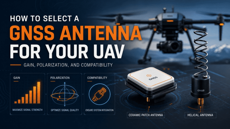
Every failed HAS integration we see starts in the same place. The receiver is HAS-capable, the firmware is current, and there are still no corrections – because the antenna stops below the E6 band. HAS lives at 1278.75 MHz, so the antenna specification has to cover E6 explicitly. Check that line item before touching receiver configuration. The same applies to cable runs and splitters on larger airframes, which can quietly attenuate E6 more than L1.
5. Enabling HAS on a Septentrio UAV Receiver
On a receiver with the PPPGalileoHAS feature the sequence is short:
- Connect an antenna that covers E6 at 1278.75 MHz.
- Make sure E6-B tracking and usage are on (normally default). If not:
setSignalTracking, +GALE6BC <CR>setSignalUsage, ,+GALE6BC <CR> - Let the receiver decode and apply the PPP corrections automatically – allow several minutes of convergence.
- Confirm the fix is in the right mode: the Mode field of PVTCartesian / PVTGeodetic should read “PPP” with Galileo time.
6. Which Mosaic-G5 Modules Fit Which UAV Job
The GSC list of receivers supporting Galileo HAS includes five Mosaic-G5 variants, all with E6B as the HAS channel:
| Module | Target application (GSC list) | HAS channel |
|---|---|---|
| Mosaic-G5 P3 | UAVs, robotics | E6B |
| Mosaic-G5 P3H | UAVs, robotics | E6B |
| Mosaic-G5 P6 | Survey and construction, industrial automation, UAVs | E6B |
| Mosaic-G5 T | Timing and synchronisation, critical infrastructure | E6B |
| Mosaic-G5 P8 | APNT, rail, maritime, mission-critical operations | E6B |
The list is compiled from vendor declarations to the GSC; appearing on it is not a certification. For airframes, P3 and P3H are the compact options, while P6 is the choice when the same platform also flies survey-grade mapping missions.
7. HAS, RTK and BeiDou PPP-B2b Side by Side
The practical comparison for a UAV integrator, using the official published figures:
| Item | Galileo HAS | BeiDou PPP-B2b |
|---|---|---|
| Operator | EU Galileo system (EUSPA / European Commission) | China’s BeiDou Navigation Satellite System |
| Cost | Free | Open and free |
| Delivery to the drone | E6-B broadcast from Galileo satellites + optional internet (IDD / NTRIP) | B2b broadcast from BeiDou GEO satellites |
| Data rate | 448 bit/s per satellite | 500 bit/s |
| Coverage | SL1 targets global coverage, phased per the official roadmap | China and surrounding regions (measured availability above 80% in China, broadly above 70% across Asia) |
| Corrected constellations | Galileo + GPS | Primarily BeiDou, multi-constellation expansion planned |
| Accuracy | Official target (95%): 20 cm horizontal / 40 cm vertical; typical (68%): ≤25/30 cm Galileo-only, ≤15/20 cm Galileo+GPS | Real-time decimeter level official; published studies report centimetre level static and decimeter level kinematic |
| Convergence | SL1 target 300 s, SL2 target 100 s | Not published in the same form |
| What the airframe needs | E6-B decoding + PPP engine | B2b reception/decoding + PPP engine |
RTK, by contrast, is a differential service: it needs a base station within radio or network reach, but converges in seconds and can deliver centimetre-level absolute accuracy. HAS is what you fly when there is no base station to fly with.
8. Field Test Figures
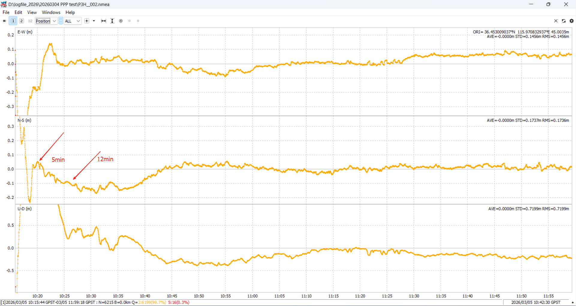
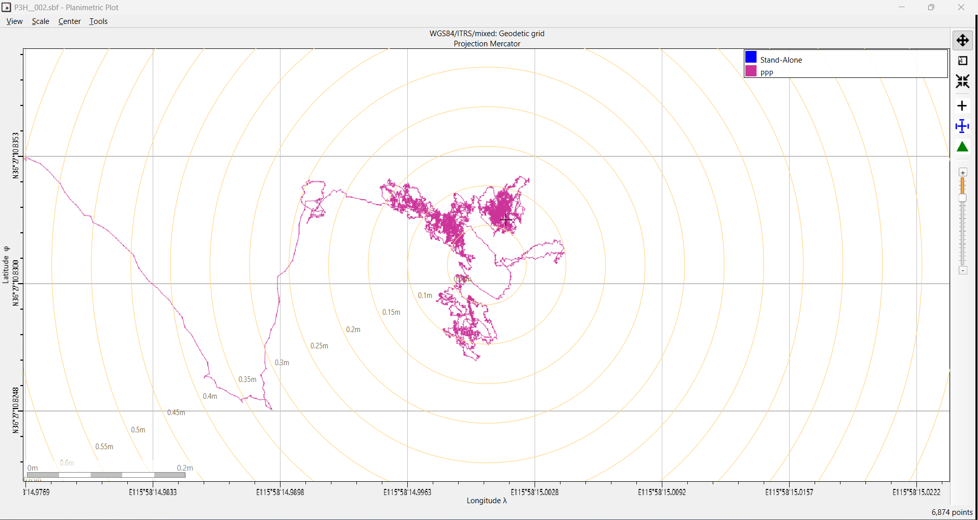
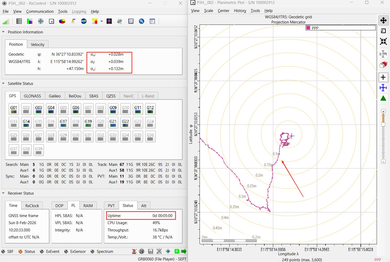
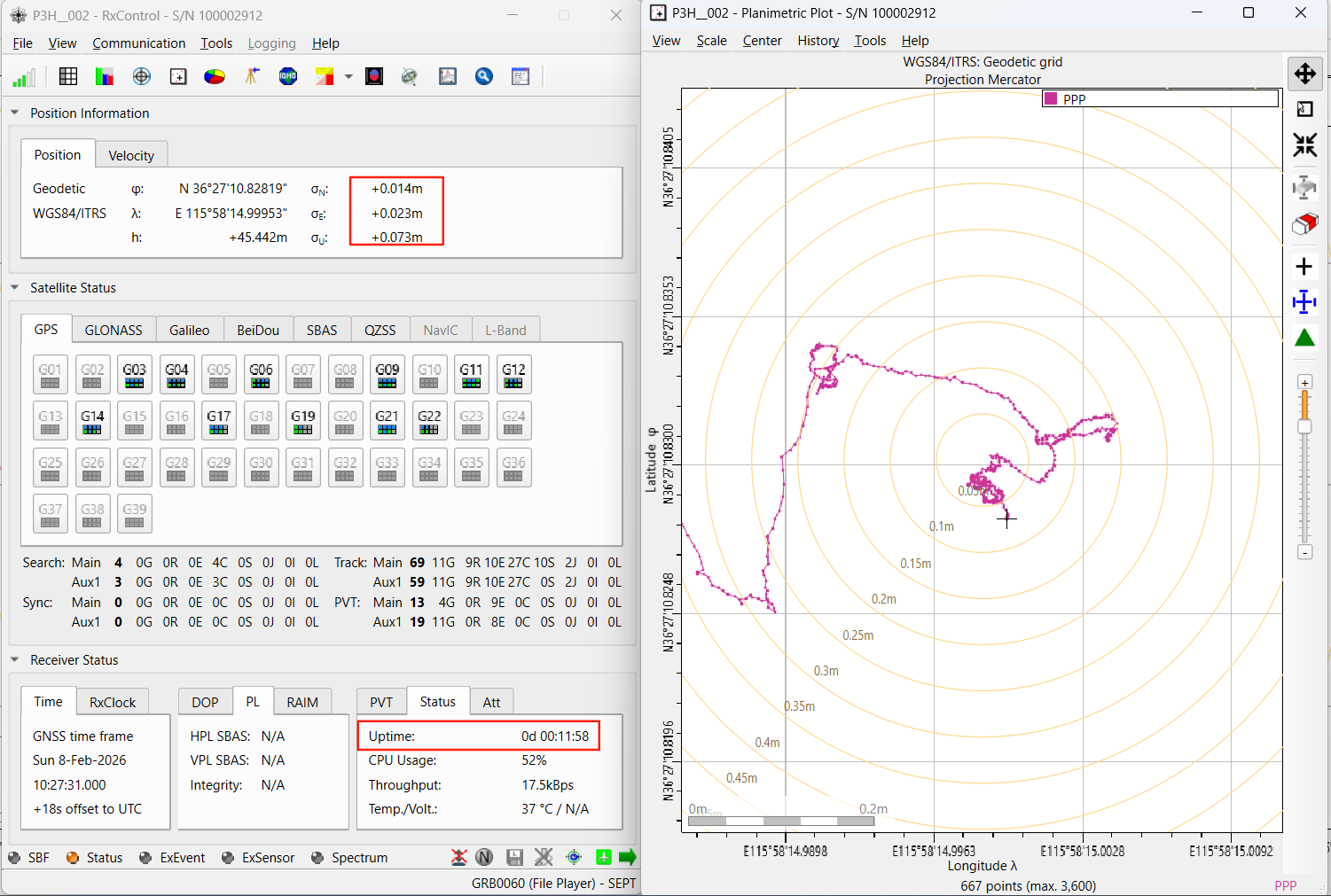
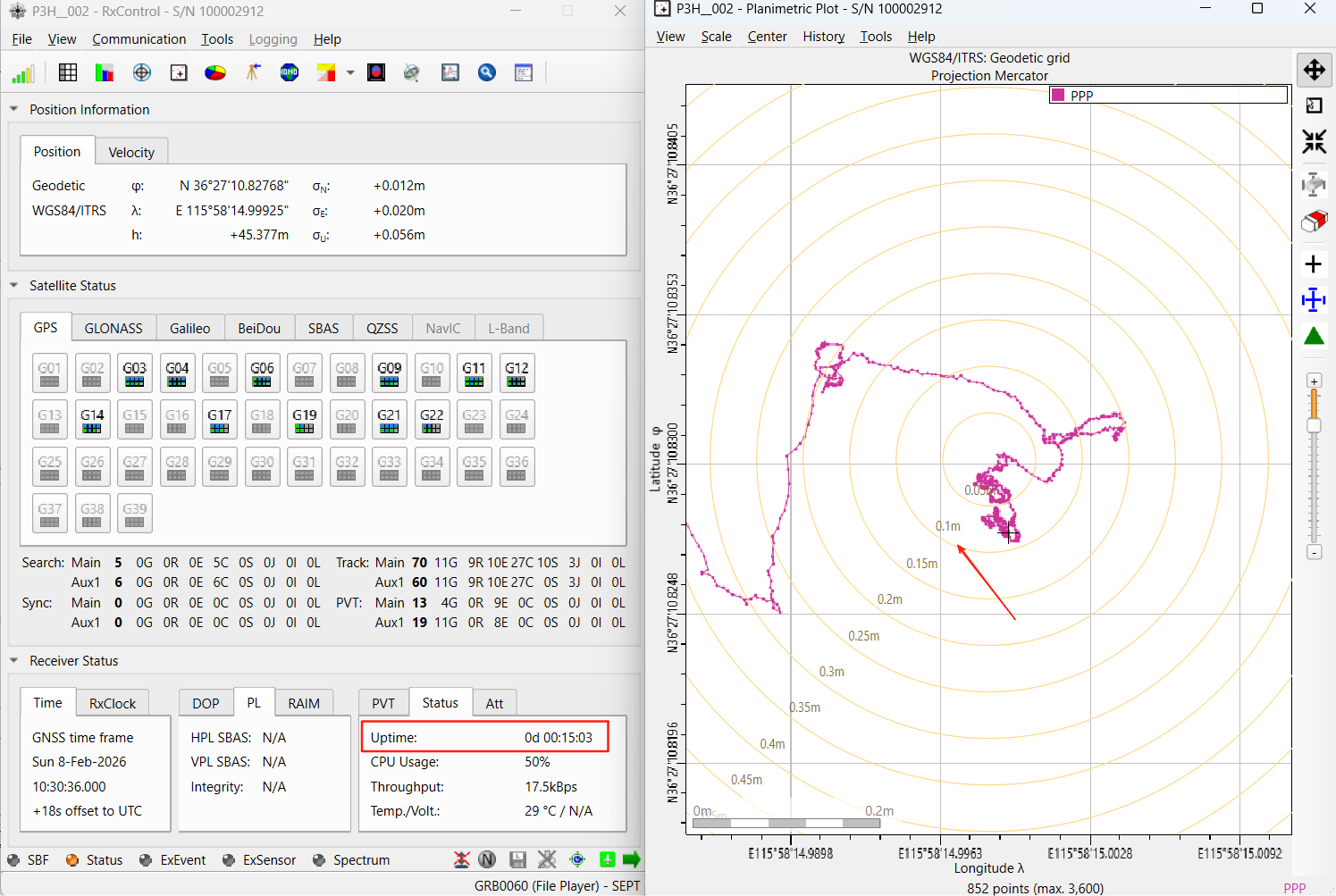
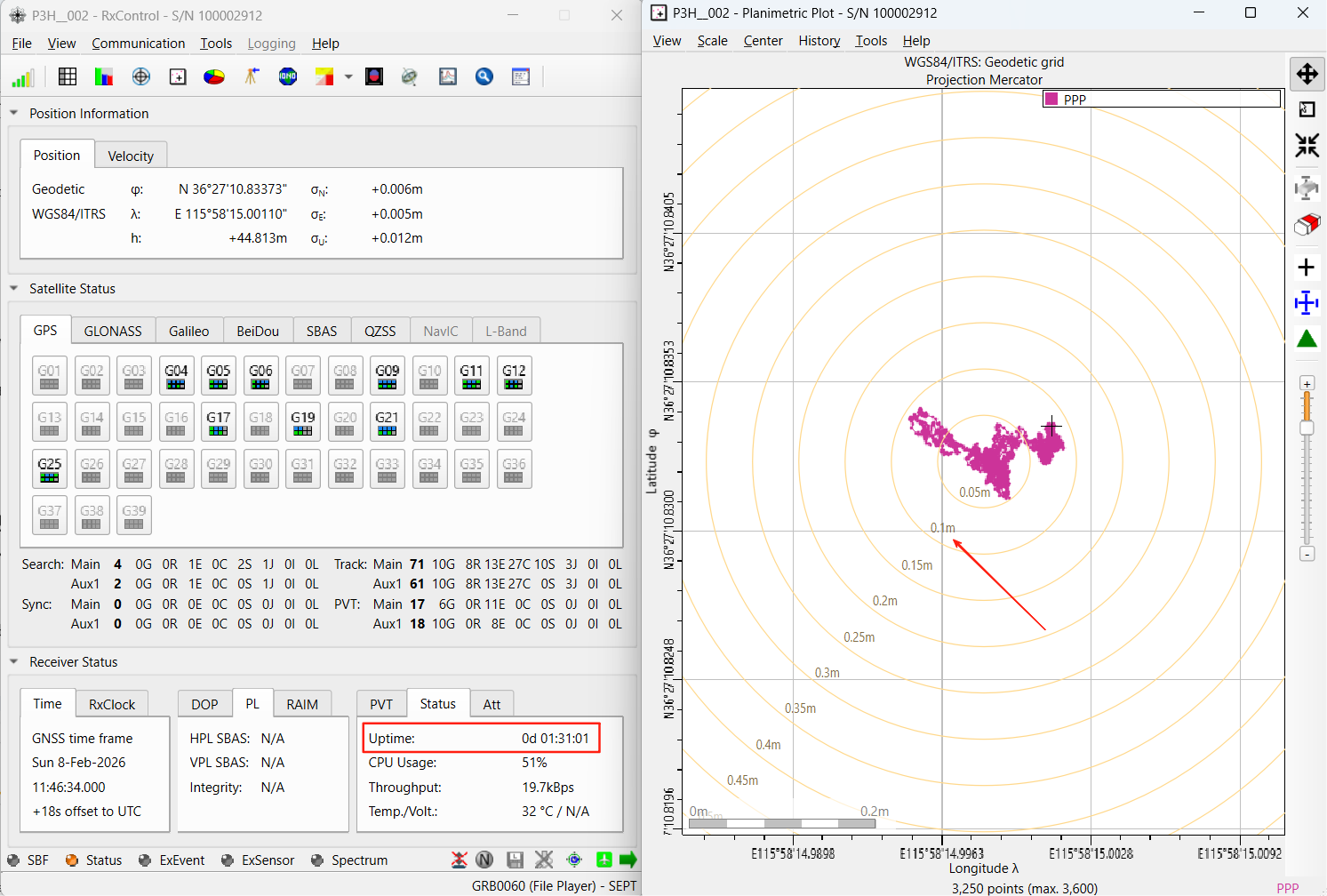
The measurements were taken with a Mosaic-G5 P3H in a specific outdoor test environment and are illustrative only – not a service commitment. Real accuracy varies with visible satellite count, sky obstruction and the quality of the receiver’s PPP engine.
9. Sources
- GSC-Europa: Galileo High Accuracy Service (HAS), HAS Internet Data Distribution and the receivers-supporting-HAS list (accessed September 2026)
- European Union: Galileo HAS Service Definition Document, Issue 1.0, January 2023
- Galileo HAS Signal-in-Space ICD and HAS IDD ICD (GSC)
- Guo Fei et al., BeiDou-3 PPP-B2b signal accuracy and PPP performance assessment, Journal of Nanjing University of Information Science and Technology, 2022
- Septentrio receiver documentation (Galileo HAS configuration)
Published: September 10, 2026 · Source document: Galileo HAS technology and application brief v1.1 (including Mosaic-G5 P3H test results). Septentrio world wide largest dealer ‑ Nanjing Hongcheng.
10. Frequently Asked Questions
Does Galileo HAS work on a drone without an internet connection?
Yes. The HAS corrections travel inside the Galileo E6-B signal, so the aircraft only needs a receiver that can track E6 (1278.75 MHz) and decode the HAS data. The NTRIP-based IDD route is an optional second channel for ground-station setups that already have a data link.
What is the single biggest mistake when adding HAS to a UAV?
Using an antenna that does not cover the E6 band. A receiver can be perfectly HAS-capable and still show no HAS corrections if the antenna stops at L1/L2. Check that the antenna specification includes 1278.75 MHz before troubleshooting anything else on the receiver side.
How long does HAS take to converge, and does that fit a drone mission?
In the Mosaic-G5 P3H field test it took about 5 minutes from power-on to reach 20 cm and about 12 minutes to reach 10 cm. That fits a typical pre-flight routine: power the aircraft’s GNSS up while the mission plan, payload and battery checks are completed, so the receiver is already converged at take-off.
Can HAS replace RTK for drone mapping and inspection?
For many mapping and inspection flights yes – 10 cm-class real-time accuracy with no base station and no correction subscription is enough for orthomosaic and asset-inspection work. Where absolute centimetre accuracy or a fixed local datum matters, RTK still wins; the two are complementary rather than either/or.
Which Septentrio modules should a UAV integrator look at for HAS?
The GSC support list includes the Mosaic-G5 P3, P3H, P6, T and P8, all with E6B as the HAS channel. P3 and P3H are the compact UAV and robotics modules; P6 covers survey and construction work with UAV variants. The receiver also needs the PPPGalileoHAS feature enabled.
How does HAS compare with BeiDou PPP-B2b for drones flying in Asia?
Both are free satellite PPP services with the same working principle – system broadcasts corrections, the receiver solves PPP. HAS is operated by the EU Galileo system with a dual broadcast/internet channel and corrects Galileo and GPS globally; BeiDou PPP-B2b is broadcast over GEO satellites and serves China and surrounding regions with BeiDou as the primary constellation.
Related Reading
- Galileo HAS: Free Satellite-Based PPP — Technology Guide and Mosaic-G5 P3H Field Results (gnss-solutions.com)
- Galileo HAS Explained: How Free Centimeter-Level GNSS Benefits UAVs (uav-gnss.com)
- Septentrio mosaic-G5 Pixhawk Integration Guide: RTK and Dual-Antenna Heading (uav-gnss.com)
UAV GNSS supplies the Septentrio Mosaic-G5 P3, P3H and P6 modules with E6-capable antennas for Galileo HAS and RTK integration on drones — Septentrio world wide largest dealer ‑ Nanjing Hongcheng. Email sales@uav-gnss.com for module selection or integration support.