High-Precision GNSS Technology Empowers Modern Emergency Search and Rescue
High-precision positioning and anti-jamming technology are critical for search and rescue (SAR) UAVs operating in smoke, heat, and heavy electromagnetic interference from emergency equipment. Critical steps such as rapid deployment, precise positioning, real-time path planning, and marking of target coordinates place high demands on positioning accuracy. Traditional meter-level or decimeter-level accuracy cannot meet the core requirements of SAR missions.
Why Is Centimeter-Level GNSS Accuracy Crucial for Search and Rescue Operations?
Quad-constellation GNSS receivers achieve centimeter-level accuracy by simultaneously tracking GPS, GLONASS, Galileo, and BeiDou satellites with RTK corrections. In challenging environments such as dense forests, mountainous regions, and urban ruins, precise GNSS positioning is the key technological foundation ensuring that drone SAR operations are efficient, reliable, and coordinated.
Core Advantages of the Septentrio mosaic-G5 P1 GNSS Receiver
The mosaic-G5 P1 is a high-precision spatio-temporal positioning system specifically designed for SAR drones, providing reliable centimeter-level positioning in an extremely compact form factor for demanding missions in complex terrain, harsh weather, and electromagnetically challenging environments.
All-Constellation, Multi-Frequency GNSS Performance
Despite its compact size of only 22.8 x 16.4 x 2.4 mm, the mosaic-G5 P1 features:
- 789 hardware channels for simultaneously tracking all visible satellite signals
- Supports all major constellations: GPS, GLONASS, BeiDou, Galileo, QZSS
- Triple-frequency tracking (L1/L2/L5 bands) enhancing signal lock robustness
- Maintains stable positioning in mountains, dense forests, canyons, and urban building clusters
GNSS+ Technology for Extreme Environments
The patented Septentrio GNSS+ technology suite ensures signal integrity under conditions present at SAR sites:
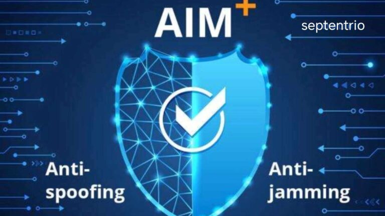
- AIM+ Basic: Interference and spoofing signal detection and suppression
- APME+: Multipath mitigation reducing interference from reflected signals off buildings, rocks, and trees
- LOCK+: Maintains stable tracking under high vibration and strong wind gusts
- RAIM+: Receiver Autonomous Integrity Monitoring providing real-time positioning trust level indications
These technologies deliver sustained centimeter-level RTK positioning accuracy:
- Horizontal Accuracy: 0.6 cm + 0.5 ppm
- Vertical Accuracy: 1.0 cm + 1 ppm
Integration Advantages in Search and Rescue Drone Platforms
High-Precision Target Positioning and Path Planning
Supporting update rates up to 5 Hz with under 10 ms latency, the mosaic-G5 P1 ensures centimeter-level trajectory control and precise target coordinate marking during high-speed flight.
Low Power Consumption for Extended Endurance
Typical power consumption of only 0.44 W (max 0.57 W) significantly extends the drone’s single-flight search duration, supporting continuous patrols over large areas.
Strong Environmental Adaptability
Operating temperature range of -40°C to +85°C, ENV-STD-810H compliant for vibration and shock, designed to perform under extreme weather conditions.
Rapid Deployment
Cold start under 35 seconds, hot start under 10 seconds, and re-acquisition in just 1 second for rapid response in emergency SAR.
The Precision Positioning Cornerstone for Search and Rescue Drones
Enhancing Search Efficiency and Success Rate
Centimeter-level positioning ensures that location information for detected targets, signs of life, or critical supplies is precise and reliable, providing dependable navigation for ground rescue teams.
Easy Integration and Multi-Platform Compatibility
Comes with complete interface documentation, SDK, and API support with SBF, NMEA, RTCM protocol compatibility for rapid integration into fixed-wing, multi-rotor, and hybrid SAR drone platforms.
Summary
- Septentrio mosaic-G5 P1 provides centimeter-level RTK positioning for SAR drones
- 789-channel, all-constellation, multi-frequency tracking ensures signal stability in complex terrain
- GNSS+ technologies including AIM+, APME+, LOCK+, and RAIM+ counter interference, multipath, and vibration
- Ultra-low power consumption and compact design support long-endurance continuous search
- Wide operating temperature range meets demanding outdoor and emergency environment requirements
Related GNSS Products
- HB21 GNSS Box Receiver — All-in-one RTK receiver with integrated 4G LTE, heading, and data logging
- HB6 GNSS Box Receiver — Compact quad-constellation RTK receiver powered by Septentrio Mosaic X5
- EV322 GNSS Receiver — Lightweight RTK receiver for UAVs and autonomous systems
- AIM+ Anti-Jamming Technology — Advanced interference and spoofing protection
Browse our full GNSS receiver collection for professional UAV applications.
Frequently Asked Questions
Which GNSS receiver is most suitable for SAR drones?
The Septentrio mosaic-G5 P1 GNSS receiver, with its centimeter-level RTK accuracy, powerful anti-interference capabilities, ultra-low power consumption, and fast start-up, is ideally suited for integration into SAR drones to meet the dual needs of high-precision positioning and rapid response in complex environments.
Why do search and rescue drones need centimeter-level GNSS positioning?
Centimeter-level positioning is fundamental for ensuring precise coordinates of search targets, accurate drone flight paths, and reliable multi-drone coordination. It directly impacts the effective deployment of search resources and the probability of mission success. In SAR, even a few meters of error can mean the difference between finding a victim or missing them entirely.
How does AIM+ technology assist SAR operations?
AIM+ Basic detects and suppresses electromagnetic interference from communication equipment, power facilities, or other electronic devices at the search site. This ensures stable GNSS signal reception in complex electromagnetic environments, safeguarding positioning continuity and mission safety during critical SAR operations near disaster sites.
Can the mosaic-G5 P1 operate in forested or mountainous SAR environments?
Yes. The mosaic-G5 P1’s multi-constellation support maximizes satellite visibility in steep terrain and under tree canopy. Its wide tracking bandwidth and high sensitivity maintain lock where signals are weak. RAIM+ provides real-time integrity monitoring, alerting the flight controller if positioning quality degrades in challenging terrain.