GPS vs GNSS: What’s the Difference?
GPS (Global Positioning System) refers specifically to the US satellite constellation. GNSS (Global Navigation Satellite System) is the umbrella term covering all satellite navigation systems including GPS, GLONASS (Russia), Galileo (Europe), and BeiDou (China).
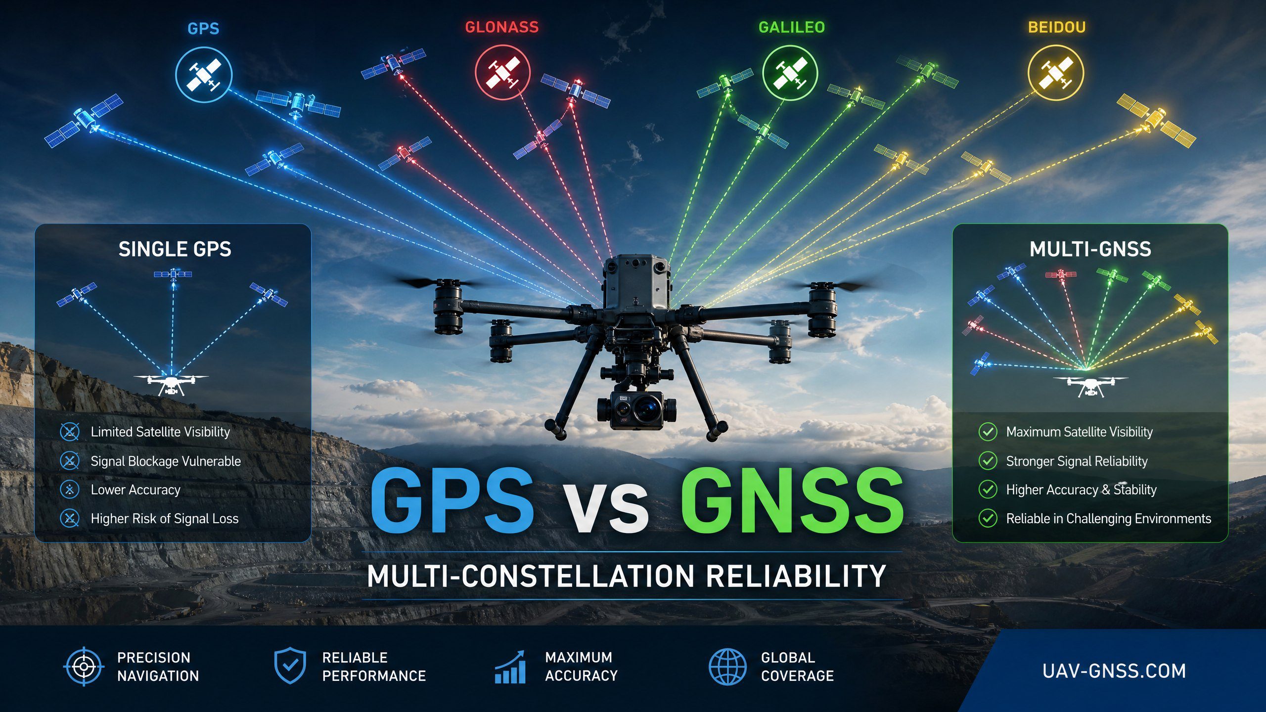
Why Multi-Constellation Matters for Drones
A single-constellation GPS receiver typically accesses 8-12 satellites. A multi-constellation GNSS receiver accesses 30-50 satellites simultaneously. This means:
- Better availability: More satellites visible in urban canyons and valleys
- Faster RTK initialization: More measurements for ambiguity resolution
- Higher reliability: Redundancy if one constellation has issues
- Improved accuracy: Better geometry with satellites from different orbits
Constellation Comparison for UAV Operations
| Constellation | Satellites | Coverage | Best For |
|---|---|---|---|
| GPS | 31 | Global | Baseline, reliable worldwide |
| Galileo | 28 | Global | High accuracy, free HAS, OSNMA security |
| BeiDou | 44 | Asia-Pacific enhanced | Best in Asia, GEO satellites for extra availability |
| GLONASS | 24 | Global, polar enhanced | Best at high latitudes, complements GPS |
Septentrio Multi-Constellation Support
All Septentrio receivers support GPS, GLONASS, Galileo, and BeiDou simultaneously. The mosaic-G5 P3 tracks 789 channels across all frequencies, ensuring maximum satellite availability for any location worldwide.
How Many Satellites Do You Really Need?
For standard GPS-only positioning, a receiver needs at least 4 satellites to calculate a 3D position. With 31 operational GPS satellites, you can typically see 8-12 at any moment from an open-sky location. But that’s the minimum viable scenario — professional drone operations need far more.
With multi-constellation GNSS, a Septentrio Mosaic-X5 receiver can track 30-50 satellites simultaneously across GPS, GLONASS, Galileo, and BeiDou. This isn’t just about having more signals — it fundamentally changes what your drone can do. More satellites means better geometry (lower PDOP), faster RTK convergence, and redundancy if one constellation has signal issues.
Multi-Frequency: The Missing Piece
Constellation count is only half the story. Modern GNSS receivers also support multiple frequencies per constellation — L1, L2, and L5 bands. Multi-frequency capability is critical because:
- Ionospheric correction: Dual-frequency receivers can measure and cancel ionospheric delay, the largest source of GNSS error for single-frequency receivers
- RTK reliability: More frequencies mean more measurements for ambiguity resolution, resulting in faster and more reliable RTK fixes
- Signal diversity: If interference affects one frequency band, the receiver can fall back to others
- Urban performance: L5 signals are more robust against multipath and diffraction in urban environments
The Septentrio mosaic-X5 supports L1, L2, and L5 bands across all four major constellations — that’s 12 distinct signal types available simultaneously for maximum positioning robustness.
Real-World Impact: Multi-Constellation vs GPS-Only
The difference between GPS-only and multi-constellation GNSS isn’t theoretical — it shows up in every flight:
| Scenario | GPS-Only | Multi-Constellation |
|---|---|---|
| Open field | 9-12 sats, 1.5m accuracy | 35-50 sats, <1m accuracy |
| Urban canyon | 4-6 sats, marginal fix | 15-25 sats, reliable RTK |
| Forest canopy | 3-5 sats, unreliable | 10-18 sats, usable fix |
| RTK initialization | 30-60 seconds | 5-15 seconds |
| Signal loss during maneuver | High risk of fix loss | Redundant backups available |
For professional operations where mission reliability matters, multi-constellation isn’t optional — it’s the baseline.
Galileo: The Game Changer for Drone Navigation
While all four constellations add value, Galileo deserves special attention for UAV applications. Galileo offers two unique capabilities:
Galileo HAS (High Accuracy Service): A free satellite-delivered correction service providing 5-15 cm accuracy without any base station or NTRIP connection. Revolutionary for drone operations in remote areas without cellular coverage. Corrections are broadcast through the Galileo E6-B signal.
Galileo OSNMA: The first publicly available GNSS signal authentication service. OSNMA digitally signs Galileo navigation messages, allowing receivers to verify that signals haven’t been spoofed. For security-sensitive operations — security, infrastructure inspection, logistics — this is critical.
BeiDou and GLONASS: Regional Strengths
With 44 satellites including GEO and IGSO satellites, BeiDou offers superior coverage in Asia-Pacific. GEO satellites remain continuously visible at fixed positions, providing exceptionally stable geometry. GLONASS, with its higher orbital inclination, offers the best coverage at high latitudes — ideal for operations in Northern Europe, Canada, or Russia.
How Multi-Constellation Improves RTK Performance
RTK (Real-Time Kinematic) positioning relies on resolving integer ambiguities in carrier phase measurements. More satellites and frequencies directly translate to faster and more reliable ambiguity resolution:
- Time to first fix: GPS-only RTK: 30-60s. Multi-constellation RTK: 5-15s — up to 4x faster
- Fix success rate: In challenging environments, multi-constellation doubles or triples RTK fix success rate
- Fix robustness: Multi-constellation maintains RTK fix where GPS-only degrades to float or single-point
- Baseline length: Supports reliable RTK over 40+ km baselines vs 20 km for GPS-only
Recommended Products for Multi-Constellation Drone Integration
- EV322 GNSS Receiver: Lightweight (60g), compact (58x58x16mm), ideal for small-to-medium UAV platforms. Powered by Septentrio Mosaic-G5.
- HB6 GNSS Box Receiver: Mid-range RTK receiver with Mosaic-X5, supporting all constellations and frequencies.
- HB21 GNSS Box Receiver: Flagship receiver with 4G LTE NTRIP, AIM+ anti-jamming, and dual-antenna heading.
All three support GPS, GLONASS, Galileo, and BeiDou simultaneously, with native SBF protocol integration for ArduPilot and PX4.
Related GNSS Products
- HB21 GNSS Box Receiver — All-in-one RTK receiver with 4G LTE, heading, and data logging
- HB6 GNSS Box Receiver — Compact RTK receiver powered by Septentrio Mosaic X5
- EV322 GNSS Receiver — Lightweight RTK receiver for UAVs and autonomous systems
- AIM+ Anti-Jamming Technology — Advanced interference and spoofing protection
Browse our full GNSS receiver collection for professional UAV applications.
Frequently Asked Questions
Is GPS-only still sufficient for professional drone operations in 2026?
No. GPS-only receivers typically access 8-12 satellites, which is inadequate for reliable RTK positioning in challenging environments. Multi-constellation GNSS receivers access 30-50 satellites, providing faster RTK fixes, better urban canyon performance, and redundancy if one constellation experiences issues.
Which GNSS constellation is most important for drones besides GPS?
Galileo is becoming the most valuable complement for professional drones — it offers free HAS corrections for sub-decimeter accuracy and OSNMA for cryptographically verified signal authentication. BeiDou is essential for operations in Asia-Pacific, while GLONASS provides the best coverage at high latitudes.
Does multi-constellation support increase GNSS receiver power consumption?
Marginally. Modern receivers like the Septentrio mosaic-X5 consume approximately 1.0 W tracking all constellations simultaneously — only about 10-15% more than GPS-only mode. The performance benefits (faster fixes, better accuracy, higher reliability) far outweigh the minimal power tradeoff.
Will my flight controller support multi-constellation GNSS receivers?
Yes, most modern flight controllers (ArduPilot, PX4, CubePilot, Holybro) support multi-constellation GNSS receivers through standard UART connections. ArduPilot and PX4 both accept SBF protocol from Septentrio receivers with GPS_TYPE=9, providing all constellation data through a single interface.