What a sunset RTK dropout usually is not
When a drone that held a fixed RTK solution all afternoon starts drifting after sunset, the first suspects are always the same: a loose antenna connector, a tired base station, a corrections link that dropped, a hot receiver. In low latitudes the more likely explanation is none of those. It is the ionosphere, and it will do exactly the same thing tomorrow evening. This note is about recognising that pattern, planning the mission window around it, and knowing what a receiver can do about it.
Flying in equatorial latitudes? Send us the airframe, the region and the accuracy target and we will match a receiver and baseline plan to it — request a quote or see the resilient GNSS receiver range.
The ionosphere as a mission-planning constraint
GNSS signals cross the charged layer between roughly 100 km and 1,000 km altitude. When electron density in that layer becomes irregular, the signal is distorted in phase and amplitude — ionospheric scintillation. Two indices describe it: S4 for amplitude and sigma-phi for phase, with S4 above 0.6 and sigma-phi above 0.3 indicating a strong event.
For flight planning, two patterns matter. Geographically, events are densest near the geomagnetic equator — Brazil, sub-Saharan Africa, India, South-East Asia, northern Australia — with weaker occurrence at the poles and documented mid-latitude events in Western Europe and the United States. Temporally, activity follows the 11-year solar cycle and has a strong daily rhythm: sunset triggers a sharp increase that lasts for hours. A late-afternoon mission and a 20:00 mission over the same site are not the same mission.
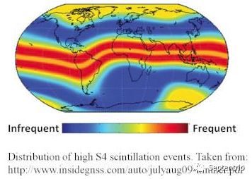
Image courtesy of Septentrio
What the failure looks like in the air
| What you observe | What is happening | What to check |
|---|---|---|
| Accuracy drifts by metres, fix type still reads fixed | Measurements are distorted but not rejected | C/N0 per band in the flight log, time of day |
| Solution drops to float without a sky-view change | Cycle slips force ambiguity re-resolution | Re-convergence time and how the controller behaves meanwhile |
| Satellites disappear and return together | Loss of lock on the affected bands | Whether it tracks sunset, not the manoeuvre |
| Payload geotags or event markers look offset | The time base and the position stream share the same distortion | PPK residuals and event-marker timing |
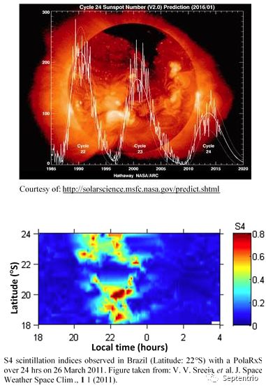
Image courtesy of Septentrio
Receiver-side handling and the base-station budget
Adding constellations does not remove scintillation, because the corruption is in the signal rather than the geometry: the affected measurements have to be identified and excluded. Receivers running Septentrio IONO+ — developed out of project work in Brazil — keep tracking under conditions that disrupt a standard receiver, recognise scintillation events and take the affected signals out of the position computation.
The consequence that usually decides a project is the baseline. With conventional RTK you need a reference-station network to interpolate the ionospheric delay and compensate at the rover. With IONO+ the delay is estimated inside the receiver, so a single base station at up to 40 km is enough, and up to 80 km while the ionosphere is quiet. For drone teams that fly from a single surveyed point, that removes the dependency on a dense correction network.
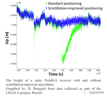
Image courtesy of Septentrio
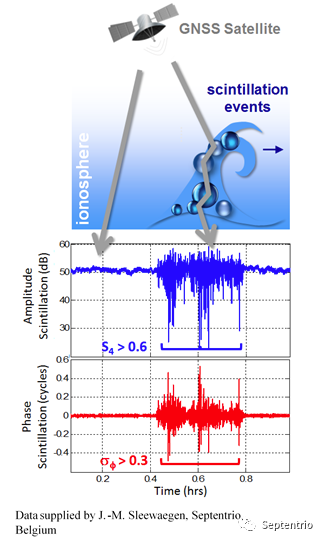
Image courtesy of Septentrio
Planning around it
- Shift the window. If the deliverable tolerates midday light, fly before the evening onset. If it does not, plan for a lower-quality section after sunset and say so in the deliverable.
- Log the evidence. C/N0 per band, fix type, satellite count and interference status in one file; a dusk onset pattern is the signature that separates scintillation from interference or a bad connector.
- Budget the recovery. Measure how long RTK takes to return to fixed after a slip, and define what the autopilot does during that window.
- Test in the evening. A platform accepted at 14:00 has not been tested for the condition it will meet at 20:00.
Receivers for equatorial operations
These platforms carry Septentrio Inside with IONO+ among the standard features:
- HB52H / HB52 ultralight RTK module — few-gram mosaic-G5 for swarm nodes and mass-limited airframes;
- HBEV322 / HBEV322H compact RTK receiver — mosaic-G5 P3H with dual-antenna heading;
- HB10 dual-antenna receiver — AsteRx-m3 Pro+ for precise position and heading;
- HB62 rugged reference station — the single base station the 40–80 km baseline case needs.
FAQ
How do I tell scintillation from interference?
Interference usually shows as elevated noise or the receiver’s interference indicator; scintillation follows the sunset pattern and the geographic latitude. Logging C/N0 per band together with interference status separates the two in one flight.
Will a dual-frequency receiver solve it?
Multi-frequency tracking helps, but the decisive factor is whether the receiver identifies and excludes scintillation-affected measurements instead of allowing them into the solution.
Is this a problem outside the tropics?
Less often and less severely, but mid-latitude events are documented, and activity rises everywhere around solar maximum.
Sources
Septentrio technical note on ionospheric scintillation and IONO+; S4 observations from V. V. Sreeja et al., J. Space Weather Space Clim. 1 (2011); CIGALA project data (Brazil); Eview product documentation.