This RTK vs PPK for Drone Surveying guide breaks down both technologies so you can make the right choice for your surveying needs. If you are a drone surveyor, you have probably asked yourself: RTK vs PPK for drone surveying — which is better? Both technologies deliver centimeter accuracy surveying drone results, but they work very differently. Choosing the right one affects your workflow, equipment, and even whether you need ground control points (GCPs).
This guide breaks down RTK and PPK in plain language — how they work, how accurate they are, and which one suits your drone mapping projects best.
What Are RTK and PPK in Drone Surveying?
RTK stands for Real-Time Kinematic positioning. PPK stands for Post-Processed Kinematic positioning. Both are differential GNSS correction techniques that eliminate satellite positioning errors to deliver centimeter-level accuracy for drone surveying.
Here is the core difference: RTK corrects in real time during the flight via a data link between the drone, a base station, and a correction network. PPK corrects after the flight by combining the drone’s raw GNSS logs with base station data in post-processing software.
Both methods rely on a fixed base station or network of base stations that calculate the difference between their known position and the satellite signals they receive. This error correction is then applied to the drone’s position data. The result? A drone mapping without GCP workflow becomes practical — saving hours of field work while maintaining survey-grade accuracy.
For professional operators, understanding the difference between RTK and PPK is essential for choosing the right GNSS receiver for drone mapping and building an efficient surveying workflow.
For a complete selection of compatible hardware, browse our range of RTK GNSS receivers designed for professional drone surveying applications.
How Does Real-Time Kinematic (RTK) Correction Work?
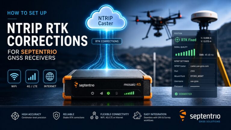
Real-Time Kinematic (RTK) positioning works by establishing a real-time data connection between a base station and the drone’s GNSS receiver. The base station — set up at a known, fixed location — continuously calculates GNSS errors and sends correction data to the rover (the drone) via a radio modem, 4G LTE, or u-blox.com/en/technologies/ntrip” target=”_blank” rel=”dofollow”>NTRIP (Networked Transport of RTCM via Internet Protocol).
Here is the step-by-step process:
- Base station setup: A GNSS base station is placed at a surveyed point or uses a real-time correction service (e.g., CORS network).
- Error calculation: The base station compares its known position with satellite measurements to compute correction vectors.
- Real-time transmission: Corrections are streamed to the drone via radio, 4G, or NTRIP at 1-10 Hz.
- Onboard correction: The drone’s RTK-enabled GNSS receiver applies corrections immediately, achieving 2-5 cm accuracy during flight.
- Direct geotagging: Each image captured by the drone is geotagged with RTK-corrected coordinates in real time.
The biggest advantage of RTK is instant results. You can verify accuracy in the field and export geotagged orthophotos immediately after landing. However, RTK requires a reliable correction link at all times. If the data link drops — common in mountainous terrain, dense urban areas, or beyond radio range — the drone reverts to standard GNSS accuracy (several meters), potentially ruining the mission.
For operators who need reliable RTK performance, the HB21 GNSS Box Receiver offers 4G LTE connectivity for uninterrupted correction streaming over cellular networks.
How Does Post-Processed Kinematic (PPK) Correction Work?
Post-Processed Kinematic (PPK) takes a different approach. Instead of correcting position data during the flight, PPK logs raw GNSS observations on both the drone and the base station, then processes them together after the mission is complete.
Here is how PPK works step by step:
- Raw data logging: The drone’s GNSS receiver logs raw satellite observations (carrier phase, pseudorange) at 5-20 Hz throughout the flight.
- Base station logging: A base station at a known fixed location simultaneously logs the same raw GNSS data.
- Post-flight processing: After landing, dedicated PPK software (like RTKLIB, Trimble Business Center, or Emlid Studio) combines both logs to compute a precise flight trajectory.
- Image geotagging: The corrected trajectory is applied to each image’s timestamp to generate accurate geotags.
- Final output: Exported images carry centimeter-accurate coordinates ready for photogrammetry processing.
The main advantage of PPK is freedom from data link constraints. Since no real-time correction is needed, PPK works perfectly in challenging environments — deep valleys, urban canyons, forest canopies, or miles beyond radio range. It also eliminates the risk of mid-flight correction loss that can compromise RTK missions.
The trade-off is delayed results. You cannot verify accuracy until you return to the office and process the data. If the base station data is corrupted or the drone’s logs have gaps, you may need to re-fly the mission.
For operators who value reliability over instant results — especially in difficult terrain — PPK is often the preferred choice. Our EV322 GNSS Receiver supports both RTK and PPK modes, giving you maximum flexibility.
RTK vs PPK: What’s the Difference in Accuracy?
Both RTK and PPK deliver essentially the same level of accuracy — 1-5 cm horizontal and 2-10 cm vertical under good conditions. However, there are subtle differences worth understanding.
A key advantage of PPK is the ability to re-process ambiguous epochs. If the RTK fix temporarily drops out, those images may be lost. With PPK, you can often recover those epochs during post-processing because the software can re-calculate the integer ambiguity resolution from the raw data. This makes PPK more forgiving in challenging GNSS environments.
Can You Survey Without GCPs Using RTK or PPK?
Yes — this is the biggest benefit of both RTK and PPK. With either technology, you can achieve drone surveying without GCP (ground control points). This saves enormous amounts of field time, especially over large or inaccessible areas.
However, there are important caveats:
RTK without GCPs works well when the RTK fix is maintained through the entire flight. If you lose the RTK fix for even a few seconds, those images will have degraded accuracy. Some operators use a hybrid approach: RTK for the primary geotagging plus a few checkpoints to validate accuracy.
PPK without GCPs is generally more reliable because post-processing can recover from temporary signal loss. Many professional surveys using PPK can match GCP-based accuracy (1-3 cm) without placing a single ground target.
Recommendations for zero-GCP workflows:
- For open terrain (agriculture, mining, construction): RTK without GCPs delivers excellent results.
- For complex terrain (valleys, forests, urban): PPK without GCPs is safer.
- For maximum accuracy (<1 cm): Use either RTK or PPK plus 3-5 checkpoints for validation.
- For regulatory compliance: Some survey standards still require GCPs regardless of RTK/PPK use — check local requirements.
In practice, most professional drone surveyors use RTK or PPK to reduce GCP requirements by 80-100%. Instead of placing 20+ GCPs for a 100-hectare site, you might place 3-5 validation points. That is a dramatic time saving — from a full day of field work to one hour.
Whether you choose RTK or PPK, the right centimeter accuracy surveying drone setup can transform your productivity. At precision GNSS solutions provider UAV GNSS, we help surveyors build optimized workflows for both approaches.
Which Is Better for Drone Mapping: RTK or PPK?
The answer depends on your specific survey conditions and workflow preferences. Neither is universally “better” — they excel in different scenarios.
When comparing RTK vs PPK for Drone Surveying, the answer depends on your specific application. RTK works best in areas with reliable cellular coverage, while PPK excels in remote locations without correction signal.
Consider using both RTK and PPK together on the same GNSS receiver. Many modern receivers — including our UAV GNSS products — can log raw data for PPK processing while simultaneously outputting RTK corrections. This gives you the best of both worlds: instant field results and a backup PPK solution for quality assurance.
If you fly a fleet of drones or work across diverse environments, having receivers that support both modes is the smartest investment. You never know when you might fly into an area with poor RTK coverage.
What GNSS Receiver Do You Need for RTK/PPK Drone Surveying?
To use RTK or PPK for drone surveying, you need a GNSS receiver that supports carrier-phase tracking on multiple frequencies and constellations. Consumer-grade GPS receivers (like those in standard DJI drones) do not support RTK or PPK — they only deliver meter-level accuracy.
Here are the key specifications to look for in a GNSS receiver for drone mapping:
- Multi-constellation support: At minimum, GPS + GLONASS + Galileo + BeiDou (quad-constellation). More satellites = faster fix and better accuracy.
- Dual-frequency or multi-frequency: L1/L2 or L1/L2/L5 for ionospheric error correction.
- RTCM 3.x output: For RTK correction input/output compatibility.
- Raw data logging: For PPK post-processing (RINEX 3.x format).
- Sampling rate: At least 5 Hz for drone applications; 10-20 Hz is ideal.
- Low power consumption: Lightweight and compact for UAV integration.
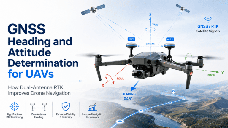
- Dual-antenna heading support (optional): For drones that need accurate yaw information.
The HB21 GNSS Box Receiver ticks all these boxes: multi-frequency, quad-constellation, RTK + PPK support, 4G LTE for NTRIP corrections, and data logging at 20 Hz. For smaller drones, the EV322 GNSS Receiver offers the same Septentrio mosaic™ G5 chipset in a lightweight form factor.
Best GNSS Receiver for Drone Surveying in 2026
Based on our evaluation of accuracy, reliability, and feature set, here are the top best GNSS receiver for drone surveying picks for 2026:
For the best RTK vs PPK for Drone Surveying results, the Septentrio mosaic-X5 with AIM+ technology offers the highest accuracy with both RTK and PPK support, making it ideal for professional surveying operations.
- HB21 GNSS Box Receiver — Best all-rounder. Octa-constellation, multi-frequency RTK/PPK receiver with 4G LTE, heading, and onboard data logging. Ideal for professional drone operators who survey diverse terrains.
- EV322 GNSS Receiver — Best lightweight option. Powered by Septentrio mosaic™ G5, offering survey-grade RTK/PPK in a compact form factor. Perfect for small to medium drones.
- HB6 GNSS Box Receiver — Best value. Compact quad-constellation RTK receiver powered by Septentrio mosaic™ X5, balancing cost and performance for cost-conscious operators.
All three receivers are available at UAV GNSS Receivers. They support both RTK and PPK workflows, so you can choose the best method for each mission without changing hardware.
Frequently Asked Questions
Is RTK or PPK more accurate for drone surveying?
Both deliver similar accuracy — typically 1-5 cm horizontal and 2-10 cm vertical. The practical accuracy difference is negligible. What matters more is whether your environment supports reliable RTK correction links. In open sky conditions, both perform equally well.
Q: Is RTK vs PPK for Drone Surveying better for accuracy?
A: Both RTK and PPK deliver centimeter-level accuracy. The choice between RTK vs PPK for Drone Surveying depends on your workflow, budget, and survey environment rather than accuracy alone.
Can I use PPK without a base station?
Yes — you can use a Virtual Reference Station (VRS) network or public CORS (Continuously Operating Reference Station) data for PPK processing. Many countries have free CORS networks that provide base station RINEX data. This eliminates the need to set up your own base station, though accuracy may be slightly lower than a dedicated base within 10-20 km of the survey site.
Do I need both RTK and PPK on my GNSS receiver?
Having both is highly recommended. Many professional receivers log raw GNSS data for PPK as a backup while outputting RTK corrections in real time. This “dual-mode” approach gives you instant results in the field and a fallback if the RTK fix drops out. It adds no extra hardware cost — just ensure your receiver supports simultaneous RTK and raw data logging.
Does PPK work with any drone?
PPK works with any drone that carries a compatible GNSS receiver capable of logging raw carrier-phase observations at 5 Hz or higher. You cannot use a drone’s built-in GPS for PPK — you must add a survey-grade GNSS receiver that logs RINEX data. Most professional mapping drones accept external GNSS receivers, and the corrected trajectory is applied to image timestamps during post-processing.
Need Help Choosing Between RTK and PPK?
Our team can help you select the right GNSS receiver for your drone surveying workflow. Contact us for a free consultation or browse our GNSS receiver collection.
Related GNSS Products
- HB21 GNSS Box Receiver — All-in-one RTK receiver with 4G LTE, heading, and data logging.
- HB6 GNSS Box Receiver — Compact quad-constellation RTK receiver.
- EV322 GNSS Receiver — Lightweight RTK receiver for UAVs.
- AIM+ Anti-Jamming Technology — Professional-grade protection.