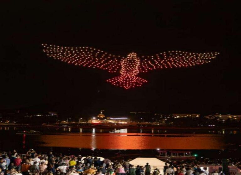
Drone light shows and aerial lighting displays have grown from novelty acts into mainstream entertainment. Coordinating hundreds of drones in a night sky demands positioning precision that consumer GNSS modules simply cannot deliver. The Septentrio Mosaic-G5 P3H GNSS receiver provides the centimeter-level accuracy and dual-antenna heading that make large-scale drone light shows safe, reliable, and spectacular.
Why Lighting Drones Need Survey-Grade GNSS
A drone light show with 500 aircraft requires each drone to hold its position within centimeters. When drones are flying 50 to 100 meters in the air, even a 0.5-degree heading error translates into nearly a meter of lateral displacement. In a dense formation, that displacement means collisions, which cascade into show failures or safety incidents.
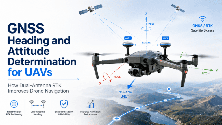
The Mosaic-G5 P3H solves this with its dual-antenna GNSS compass. By processing carrier-phase differences between two antennas separated by a known baseline, it measures true heading with 0.07 to 0.11 degree accuracy. This sub-degree heading precision keeps every drone in its assigned position, even during yaw maneuvers that would confuse single-antenna receivers.
Dual-Antenna Heading for Formation Stability
Single-antenna GNSS receivers estimate heading from the direction of travel. When a lighting drone hovers — which it does for most of a show — the velocity drops below the threshold where heading can be reliably estimated. The GNSS compass in the P3H eliminates this problem entirely. It provides heading at zero velocity, meaning each drone knows its orientation even when stationary in the show formation.
This is critical for shows involving coordinated yaw maneuvers, spiral formations, or drones carrying directional LED arrays. Without accurate heading, the LED panels point in the wrong direction, and the visual effect breaks apart. With the P3H’s dual-antenna heading, every drone faces exactly where the choreography specifies.
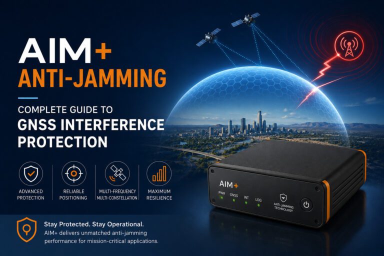
AIM+ Anti-Jamming for Public Event Environments
Drone light shows happen at public events — stadiums, festivals, city squares. These environments are full of RF interference: broadcast transmitters, mobile phone networks, two-way radios, and Wi-Fi hotspots. The AIM+ technology in the Mosaic-G5 P3H provides real-time interference monitoring and adaptive filtering that suppresses jamming while preserving clean GNSS signals.
The practical impact is straightforward: the show stays in the air. Without AIM+, a sudden interference spike from a nearby broadcast van or mobile tower can cause GNSS receivers to lose lock, sending drones into failsafe mode mid-show. With AIM+, the interference is filtered out before it reaches the positioning engine, and the formation holds.
Multi-Constellation Tracking for Urban Sky Coverage
Light shows often take place in urban areas with tall buildings, bridges, and monuments that block parts of the sky. The Mosaic-G5 P3H tracks GPS, GLONASS, Galileo, and BeiDou simultaneously. This multi-constellation capability provides 30 or more visible satellites even in a partially obstructed sky, ensuring continuous RTK positioning throughout the show.
Multi-frequency tracking on L1, L2, and L5 bands also corrects for ionospheric errors that accumulate during the evening hours when light shows typically occur. The receiver maintains a fixed RTK solution regardless of atmospheric conditions, time of day, or seasonal variations.
Centimeter-Level RTK for Dense Formations
The Mosaic-G5 P3H delivers centimeter-level RTK accuracy in real time. For a light show designer, this means drones can fly as close as 2 to 3 meters apart — safe enough for visual separation but tight enough to create stunning collective imagery. The RTK engine converges in seconds and maintains its fixed solution through all phases of flight.
This precision also enables complex 3D formations that rise, fall, and rotate as a single volume of light. Each drone’s position relative to its neighbors is known to well under a meter, allowing the show software to compute collision-free paths through dynamic formation changes.
Relationship to Other Drone Show GNSS Solutions
For teams deploying lighting drones, the Mosaic-G5 P3H pairs naturally with our mosaic-X5 GNSS receiver for lighting drone applications, which offers similar RTK performance in a single-antenna configuration. The P3H adds the dual-antenna heading advantage for shows requiring yaw control.
For film and television drone cinematography, the mosaic-X5 in film and television drone cinematography covers production environments where repeatable camera paths matter more than formation stability. Both use cases benefit from the EV322 GNSS receiver as a base station for RTK corrections.
Integration with Light Show Control Software
The Mosaic-G5 P3H outputs position and heading data through standard NMEA and binary protocols over UART or USB. It integrates with Pixhawk, Cube, and other ArduPilot or PX4 flight controllers commonly used in light show platforms. The receiver’s compact 19 g form factor and under 1 W power consumption minimize payload impact, allowing more battery capacity for LED lighting arrays.
Why the Mosaic-G5 P3H Is the Right GNSS Receiver for Lighting Drones
- Dual-antenna GNSS compass with sub-degree heading accuracy
- Centimeter-level RTK positioning for dense drone formations
- AIM+ anti-jamming for interference-heavy event environments
- Multi-constellation, multi-frequency tracking for urban operations
- Heading available at zero velocity — essential for hover formations
- 19 g module weight for payload-constrained lighting platforms
- Compatible with Pixhawk, ArduPilot, and PX4 flight controllers
For authoritative research on GNSS performance in drone applications, refer to the MDPI Drones journal for peer-reviewed studies on multi-constellation positioning and formation flight.