The Critical Role of High-Precision GNSS in Wildlife Conservation
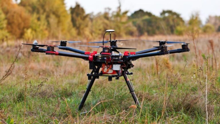
As ecological protection technology advances toward intelligence and refinement, drones have become core tools for animal tracking, habitat monitoring, anti-poaching patrols, and population surveys. Wildlife conservation missions demand extremely high continuity and reliability of spatiotemporal information. Drones must continuously provide precise position, attitude, and timestamps in complex natural environments such as jungles, grasslands, and mountainous areas. The Septentrio AsteRx-m3 Pro+, a high-performance, low-power GNSS board, delivers centimeter-level Real-Time Kinematic (RTK) positioning and 3D attitude sensing capabilities for conservation drones, serving as the key sensor to ensure monitoring data meets scientific research and law enforcement standards.
Why Do Wildlife Conservation Drones Need High-Performance GNSS Boards?
Wildlife conservation operations take place in special and challenging environments:
- Precise Tracking and Data Correlation: Studies on animal movement trajectories, habitat utilization, and anti-poaching investigations require drones to provide centimeter-level positioning, ensuring accurate binding of observation points, infrared thermal images, and video data with geographic coordinates.
- Complex Natural Environment Challenges: Satellite signals are prone to obstruction and multipath interference in dense forests, canyons, and river areas, with risks of natural or man-made radio interference.
- Stealth and Stable Operation Requirements: Monitoring missions demand quiet and smooth drone flights to avoid disturbing animals, while maintaining stable positioning and attitude during high-dynamic flights (e.g., tracking moving targets).
- Long-Duration Endurance and Reliability: Protected areas are vast, and missions last for extended periods. Navigation devices must be ultra-low power and adaptable to field conditions such as humidity, large temperature differences, and vibrations.
With its exceptional positioning accuracy, powerful GNSS+ anti-jamming technology, industrial-grade reliability, and ultra-low power design, the Septentrio AsteRx-m3 Pro+ is the ideal navigation core for wildlife conservation drones to achieve precise monitoring, reliable patrolling, and efficient management.
Core Advantages: An “Ecological Sensing Hub” Tailored for Conservation Drones
The AsteRx-m3 Pro+ not only provides high-precision positioning but also delivers continuous, reliable, and secure spatiotemporal data streams for conservation work through deep GNSS fusion and a powerful software suite.
Key Performance Parameters
- Multi-Frequency, Multi-Constellation Reception: Equipped with powerful hardware channels, supporting multi-system and multi-frequency signals including GPS, BeiDou, Galileo, and GLONASS, ensuring optimal signal coverage and redundancy in any remote protected area worldwide.
- Centimeter-Level RTK Positioning Accuracy: Horizontal accuracy reaches centimeter level. Combined with RTK technology, it provides an absolutely precise geographic reference for animal location recording and habitat boundary mapping.
- High-Precision Attitude and Heading Output: delivers 3D attitude (pitch, roll) and heading data. Supports dual-antenna configuration for higher-precision true north heading measurement, free from magnetic interference.
- Advanced Anti-Jamming and Anti-Spoofing: Equipped with AIM+ technology, it can real-time monitor and suppress narrowband, broadband, and spoofing interference from natural environments or man-made devices, ensuring positioning security and credibility in complex electromagnetic environments.
- High Update Rate and Low Latency: High integrated navigation output rate and low latency ensure the drone flight control system can respond in real time, enabling smooth tracking and rapid maneuvering.
- Industrial-Grade Ruggedness and Low Power Consumption: Adopts a rugged design, adapting to wide temperature, high humidity, and vibration environments. Excellent power optimization significantly extends the endurance of drone patrol and monitoring missions.
GNSS+ Technology Suite: Ensuring Continuous and Reliable Operation in Protected Areas
- AIM+: Advanced interference monitoring and suppression, effectively countering potential communication devices, illegal jammers, or other unknown radio signals near protected areas, ensuring pure navigation signals.
- APME+: Post-processing Multipath Estimation technology, significantly reducing signal reflection errors caused by dense tree canopies, mountain slopes, and water surfaces, improving positioning accuracy in complex terrain.
- LOCK+: Enhanced tracking robustness, ensuring stable satellite signal tracking without loss of lock or positioning jumps when the drone passes through air currents, experiences motor vibration, or performs rapid maneuvers.
- IONO+: Ionospheric scintillation suppression, improving positioning stability during morning, evening, or geomagnetic activity periods, ensuring all-weather operational capability.
Easy Integration and UAV Platform Adaptability
- Compact Board Form Factor: Adopts a standard board design, facilitating integration into the drone’s internal electrical system, saving space, and optimizing overall layout.
- Rich Standard Interfaces: Provides multiple interfaces such as UART, USB, and Ethernet, supporting universal protocols including SBF, NMEA, and RTCM, enabling easy integration with mainstream flight controllers and mission payloads (e.g., infrared cameras, LiDAR).
- Comprehensive Software Support: Equipped with a WebUI configuration interface and a powerful RxTools software suite, providing SDKs and detailed documentation, greatly simplifying development, debugging, and data processing workflows.
Typical Application Scenarios in Wildlife Conservation Drone Systems
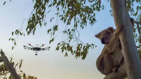
Precise Tracking of Rare Species and Behavioral Research
Based on centimeter-level positioning, drones can perform long-duration, high-precision trajectory tracking of animals equipped with radio collars or identified through image recognition. Combined with high-precision timestamps, it provides quantitative data for animal behavioral ecology research.
Habitat Change and Illegal Activity Monitoring
By regularly executing high-precision flight routes and comparing orthophotos and 3D models from different periods, it can accurately monitor habitat changes and human activity traces such as deforestation, land encroachment, and poaching paths.
Anti-Poaching Patrols and Emergency Response
At night or in severe weather, combined with infrared thermal imaging payloads, precise real-time positioning, and stable attitude, drones can conduct large-scale stealth patrols, quickly locate suspicious heat sources, and provide accurate coordinate guidance for rangers.
Wildlife Population Survey and Health Assessment
Execute automated grid flights in vast areas, perform AI recognition and counting through georeferenced images, evaluate wildlife population size, distribution, and health status, and provide data support for conservation decision-making.
Summary
-Core Positioning: The Septentrio AsteRx-m3 Pro+ is a high-performance, low-power GNSS board specifically designed for harsh field environments, providing centimeter-level positioning and stable attitude benchmarks for wildlife conservation drones.
-Technical Support: The GNSS+ technology suite (AIM+, APME+, LOCK+, IONO+) achieves anti-jamming, anti-multipath, high-dynamic tracking, and all-weather stability, addressing various challenges in nature reserves.
-Application Value: Empowers drones to perform precise animal tracking, habitat monitoring, anti-poaching patrols, and population surveys, significantly improving the efficiency, scope, and data scientificity of conservation work.
-Easy Integration: Compact form factor, rich interfaces, open protocols, and comprehensive software tools enable rapid integration into various conservation drone platforms, serving as a core component for building intelligent ecological protection monitoring networks.
Frequently Asked Questions
How does the AsteRx-m3 Pro+ ensure effective positioning in dense forests?
The AsteRx-m3 Pro+ features multi-constellation, multi-frequency tracking (544 channels) that maximizes satellite visibility under tree canopy where signals are weak. Its high-sensitivity tracking and APME+ multipath mitigation reduce signal reflection errors from tree canopies, mountain slopes, and water surfaces. For severely attenuated signals, tight coupling with an IMU maintains positioning continuity during canopy gaps.
How does the board collaborate with mission payloads like infrared thermal imagers?
The AsteRx-m3 Pro+ provides event marker pins with nanosecond-precision accuracy for synchronizing camera exposure with GNSS time. This enables precise geotagging of infrared and visual images, ensuring animal sightings, heat signatures, and location data are accurately correlated. The board also supports PPK post-processing for the highest georeferencing accuracy.
What are the power consumption and environmental specifications for long-term monitoring?
The AsteRx-m3 Pro+ consumes approximately 750 mW to 1000 mW depending on tracking mode, making it suitable for long-endurance conservation drone missions. It operates from -40°C to +85°C and complies with ENV-STD-810G for vibration and shock, ensuring reliable performance in field conditions with humidity, temperature variations, and rugged handling common in protected area operations.
How to achieve high-precision positioning in remote protected areas without network coverage?
In areas without cellular or internet coverage, PPK (Post-Processed Kinematic) is the recommended approach. Deploy a temporary GNSS base station at a known location in the reserve, or use a portable reference receiver. Both the aircraft and base station record raw observation data during flights. Post-mission processing resolves centimeter-level trajectories without requiring real-time RTK correction links.
Related GNSS Products
- HB21 GNSS Box Receiver — All-in-one RTK receiver with integrated 4G LTE, heading, and data logging.
- HB6 GNSS Box Receiver — Compact quad-constellation RTK receiver powered by Septentrio Mosaic X5.
- EV322 GNSS Receiver — Lightweight RTK receiver for UAVs and autonomous systems.
- AIM+ Anti-Jamming Technology — Advanced interference and spoofing protection.
Browse our full GNSS receiver collection for professional UAV applications.