Bridges, dams, tunnels, high-rise towers and slopes fail slowly before they fail suddenly. Settlement, creep, thermal movement and hidden corrosion accumulate in millimeters – displacements too small for the human eye, but large enough to compromise a structure’s safety. Structural health monitoring (SHM) exists to catch these changes early, and GNSS has become one of its most powerful tools because it is the only sensor class that measures absolute, three-dimensional displacement directly, without reference to the structure itself.
The stakes keep rising. More than 67,000 bridges in the United States are rated structurally deficient, and much of the world’s post-war infrastructure has passed or is approaching its original design life. The global structural health monitoring market is projected to grow from roughly USD 3.5-5.3 billion in 2025 to USD 6.9-12.7 billion by 2030-2032 – a 9-15% compound annual growth rate – with bridges and dams representing the largest application segment. This guide explains how GNSS structural monitoring works, what accuracy you can realistically achieve, and how to select receivers for millimeter-level displacement detection.
What Is GNSS Structural Monitoring?
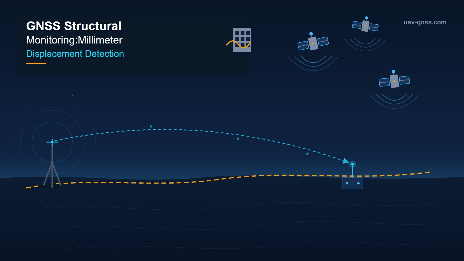
GNSS structural monitoring uses carrier-phase GNSS receivers mounted on a structure to continuously measure its position relative to a stable reference. A reference station (base) sits on geologically stable ground outside the influence of the monitored asset. One or more rover receivers are permanently installed at critical points – mid-span of a bridge, crest of a dam, top of a tower. The base and rovers process carrier-phase observations together (RTK-style double-differencing or post-processed baselines), producing coordinate time series in which changes over time represent real displacement of the structure.
Because the reference frame is defined by satellites and a fixed base, GNSS displacement measurements are absolute: they tell you where the structure moved in a global coordinate frame, not just that something changed. And because the system runs automatically around the clock, it captures displacement events when no survey crew is on site – a key advantage for early warning.
Static Displacement Monitoring
Static monitoring tracks slow, long-term deformation: foundation settlement, concrete creep, slope movement and seasonal thermal expansion. With long observation sessions and averaging, GNSS static accuracy reaches 2 mm or better in the horizontal plane and roughly 3-5 mm vertical. This is the regime used in dam deformation programs and bridge settlement surveys, where the question is “how much has this point moved over months or years?”
Dynamic Displacement Monitoring
Dynamic monitoring captures rapid movement from traffic loads, wind, seismic events or vortex shedding. Receivers sample at 5-100 Hz and resolve vibration amplitudes of 10-20 mm plus the natural frequencies of the structure. Dynamic data feeds modal analysis: frequency shifts reveal stiffness loss, damage or changed boundary conditions long before visible cracking appears. This is why leading bridge SHM systems fuse GNSS displacement with accelerometer data – GNSS provides the absolute reference the accelerometer lacks.
Why Millimeter-Level Displacement Detection Matters
Millimeter-level sensitivity is not an engineering luxury – it is the difference between early intervention and catastrophic failure. Here is what it means for the main asset classes.
Bridges
Long-span bridges deflect continuously under traffic, temperature and wind. A suspension bridge can move tens of centimeters; what matters is deviation from the expected pattern. Continuous GNSS monitoring establishes a baseline behavior envelope and flags excursions – sag increase in a main cable, abnormal deck torsion, unexpected pier settlement. The Forth Road Bridge in Scotland has been a proving ground for GNSS monitoring for two decades, and recent multi-antenna research there resolved horizontal displacement to 4-6 mm and vertical displacement to 8-10 mm using baselines of 1.2-2.0 km.
Dams
Dams are monitored for decades, and GNSS is now standard in many national dam safety programs. Crest displacement of just a few millimeters per year can indicate internal erosion or foundation problems. GNSS runs in all weather – rain, fog and darkness do not affect carrier-phase tracking – which matters because dam safety assessment cannot wait for clear skies.
High-Rise Buildings and Towers
Tall structures sway under wind, and permanent GNSS receivers at the top track both slow drift (settlement, tilt) and dynamic response (wind-induced vibration, thermal bowing). Add a second antenna and a dual-antenna receiver, and the same installation measures building twist and torsion through heading changes – attitude data that complements pure displacement measurements.
Landslides and Mining Slopes
Open-pit mines and landslide-prone slopes move centimeters before they move meters. Real-time GNSS networks with displacement-rate alarms give operators and communities the warning time that saves lives and equipment. The same receiver technology used for bridge monitoring anchors slope stability programs across the mining and civil engineering industries.
GNSS vs. Other Monitoring Technologies
No single sensor answers every monitoring question, but GNSS occupies a unique position. This comparison shows why it is the backbone of modern SHM systems:
| Technology | What it measures | Strengths | Limitations |
|---|---|---|---|
| GNSS | Absolute 3D displacement | All-weather, 24/7 automated, no line-of-sight between points, mm-cm accuracy | Requires open sky; sub-cm vertical |
| Robotic total station | Relative 3D displacement | Very high precision | Needs line-of-sight and operator attention; affected by weather |
| InSAR (satellite radar) | Broad-area surface deformation | Wide coverage, no ground access | Infrequent revisits; corner reflectors needed for mm accuracy |
| Accelerometer | Vibration and dynamic response | High rate, low cost | No absolute position (integration drift); needs GNSS reference |
| LiDAR / laser scanning | Full 3D surface geometry | Rich detail, fast campaigns | Periodic, not continuous; cm-level |
| Tiltmeter / inclinometer | Rotation and settlement at a point | Cheap, robust | Relative rotation only, not absolute position |
GNSS uniquely combines absolute 3D displacement, continuous unattended operation and full automation – which is why it is almost always the reference layer in modern SHM architectures, typically fused with accelerometers, strain gauges and tiltmeters.
How Accurate Is GNSS Displacement Monitoring? What the Research Shows
Real-world monitoring accuracy depends on baseline length, environment and processing. Recent peer-reviewed studies give realistic expectations:
- Forth Road Bridge, Scotland (Satellite Navigation, 2025): an integrated multi-antenna approach measured displacement and attitude simultaneously, achieving 4-6 mm horizontal and 8-10 mm vertical accuracy with baselines of 1.2-2.0 km, plus pitch of 0.0013 degrees and heading of 0.0004 degrees.
- Wuhan Yingwuzhou Yangtze River Bridge (Measurement Science and Technology, 2025): PPP-RTK delivered displacement accuracy and modal frequency identification comparable to RTK – including the first six modal frequencies – in a dense urban environment, with no local base station required.
- Hong Kong long-span bridge (GPS Solutions): when the baseline exceeded 3 km, RTK vertical errors reached about 15.9 mm; adding virtual reference station (VRS) corrections improved accuracy by roughly 60% to 6.0 mm. The system also demonstrated 100 Hz sampling, with dominant frequencies identified to 0.001 Hz and amplitudes to 0.1 mm.
- Curved steel box girder bridge, Japan (JSCE, 2025): RTK-GNSS combined with Kalman filtering revealed abnormal summer deformation trends and enabled real-time anomaly detection for bridge lifecycle management.
- Noise floor (MDPI Sensors, 2025): stability tests show RTK displacement noise with standard deviation below 8 mm in open environments, with multipath energy concentrated below 0.04 Hz – removable by filtering when it does not overlap structural frequencies.
The takeaway: with good site selection, multipath mitigation and appropriate processing, 4-8 mm horizontal and 8-10 mm vertical displacement detection is realistic in dynamic monitoring, while static averaging pushes resolution below 2-3 mm.
What to Look For in a GNSS Receiver for Structural Monitoring
Monitoring receivers run unattended for years, in harsh environments, and their data feeds safety-critical decisions. Evaluate these capabilities:
- Full-constellation, multi-frequency tracking: GPS, GLONASS, Galileo and BeiDou on L1/L2/L5 (and E6 for PPP services) maximize satellite availability in constrained sky views and improve vertical precision.
- High update rate: 5-100 Hz output for dynamic and modal analysis, not just 1 Hz static logging.
- RTK and PPP capability: base/rover flexibility today, with PPP-RTK readiness for base-station-free operation where network corrections are available.
- Advanced multipath mitigation: steel, concrete and water surfaces are multipath-rich; techniques like Septentrio APME+ keep measurements clean in exactly these conditions.
- Interference and spoofing protection: AIM+ style monitoring detects and mitigates jamming and spoofing, so the displacement data feeding alarms cannot be silently corrupted.
- Dual-antenna heading: measures torsion, twist and structure attitude – valuable for towers, long-span decks and tall buildings.
- Raw observation output: RINEX and RTCM3 formats for post-processing and integration with third-party SHM platforms.
- Industrial reliability: wide operating temperature range, low power consumption for solar-powered remote nodes, and 24/7 continuous operation.
- Communication and alarms: NTRIP client, Ethernet or 4G backhaul, plus configurable alarm thresholds for automatic alerting.
Septentrio-Powered Receivers for Structural Monitoring
Septentrio’s mosaic-X5, mosaic-G5 and AsteRx-m3 Pro+ modules power receivers that are a natural fit for structural monitoring: sub-centimeter RTK accuracy, AIM+ anti-jamming and anti-spoofing, APME+ multipath suppression and LOCK+ robust tracking keep measurements trustworthy for years of unattended operation. For integrators and monitoring contractors, uav-gnss.com offers ready-to-deploy receivers:
- HB10 Dual-Antenna RTK Receiver – 0.6 cm RTK accuracy and 0.15 degree heading at 100 Hz, powered by the Septentrio AsteRx-m3 Pro+. Position and orientation in one box for torsion and dynamic monitoring.
- HB21 GNSS Box Receiver – all-in-one receiver with dual-antenna heading and 4G NTRIP; ideal as the permanent reference station or as a monitoring rover.
- HB6 GNSS Box Receiver – compact, low-power receiver powered by the Septentrio mosaic-X5, well suited to solar-powered remote monitoring nodes.
All three include the AIM+ resilient GNSS technology suite that protects monitoring data against jamming and spoofing. Browse the full GNSS receiver collection for structural monitoring and infrastructure applications.
Frequently Asked Questions
Can GNSS really detect millimeter-level displacement?
Yes. Static GNSS processing achieves 2-3 mm repeatability, and published bridge studies (including the Forth Road Bridge) resolve 4-6 mm horizontal and 8-10 mm vertical displacement in continuous dynamic monitoring. Because monitoring compares a point to its own history, relative changes over time are detected even more sensitively than single-epoch absolute accuracy suggests.
What is the difference between static and dynamic GNSS monitoring?
Static monitoring tracks slow deformation – settlement, creep, thermal movement – using averaged observations over hours or days for millimeter-level resolution. Dynamic monitoring samples at 5-100 Hz to capture vibration from traffic, wind or seismic loads, resolving displacement amplitudes of 10-20 mm and the structure’s natural frequencies for modal analysis.
Do I need a base station for GNSS structural monitoring?
Classic RTK monitoring uses a local base station within a few kilometers. Alternatives include network RTK/VRS corrections over NTRIP, and PPP-RTK services – 2025 research on the Wuhan Yingwuzhou Yangtze River Bridge demonstrated PPP-RTK accuracy comparable to RTK for structural monitoring with no local base station at all.
How many GNSS receivers does a monitoring project need?
Typically one reference station plus rovers at critical points: bridge mid-span, quarter-span and piers; dam crest sections; tower tops. A long-span bridge may instrument 8-30 monitoring points, while a smaller project can start with 2-6 receivers. Dual-antenna receivers can add attitude monitoring without extra mounting points.
Can GNSS monitoring work in bad weather or at night?
Yes. GNSS is an all-weather technology – rain, fog and darkness do not degrade carrier-phase tracking, unlike optical methods. This 24/7 capability is one of the main reasons GNSS is the reference layer in modern structural health monitoring systems.
Related GNSS Products
- HB10 Dual-Antenna RTK Receiver – 0.6 cm RTK accuracy and 0.15 degree heading at 100 Hz for position and orientation monitoring
- HB21 GNSS Box Receiver – all-in-one receiver with dual-antenna heading and 4G NTRIP, ideal as reference station or rover
- HB6 GNSS Box Receiver – compact, low-power receiver powered by Septentrio mosaic-X5 for remote monitoring nodes
- AIM+ Anti-Jamming Technology – advanced interference and spoofing protection for safety-critical monitoring data
Browse our full GNSS receiver collection for structural monitoring and infrastructure applications.