Why a port story belongs in a UAV engineering notebook
Fly a multirotor between buildings, over a steel-hulled vessel or through an industrial yard and the receiver is
suddenly in the same conditions a container terminal creates on the ground: a partly blocked skyline, a dense field of
reflected signals and an RF background nobody on your team controls. That is why the recent straddle-carrier receiver
retrofit at PSA Antwerp is worth reading as a UAV case study — the constraints that shaped it are the constraints
that degrade drone positioning.
In the deployment, MGB-Tech re-engineered the terminal’s Straddle Carrier GNSS Receiver (SCGR) units around the
Septentrio mosaic-X5 module, keeping the original functions and feeding continuous container positions to the client’s
back-end system.
The environment both applications share
Steel absorbs and reflects L-band signals, stacked containers block large parts of the sky, and cranes plus moving
machinery keep changing the geometry in front of the antenna. A drone flying a low-altitude inspection or a mapping
grid over an industrial site runs into a smaller but similar version of the same problem: fewer usable satellites, more
reflected energy, and an intermittent link budget.

Steel and stacked containers: the reflections a receiver sees here are the same ones a low-flying drone meets over an industrial site.

A working container terminal. Image courtesy of PSA Antwerp.
Specs that matter to a flight controller
| Requirement | Value | Why a UAV team cares |
|---|---|---|
| Position accuracy | Centimetre-level (RTK) | Precision landing, repeatable waypoints, tight mapping lines |
| Update rate | Up to 100 Hz | Lower lag for any control loop closing on position |
| Environment | Steel structures, stacked containers, moving machinery | Multipath and sky-blocking — the urban and industrial case |
| Delivery schedule | Re-engineered in under three months | Realistic integration timeline for a receiver swap |
| Operations | Uninterrupted through the upgrade | Field-proven availability, not a lab figure |
Follow the signal chain — a drone walks the same path
The architecture of the terminal solution maps almost line for line onto an unmanned platform, with the payload and
flight controller in the role the terminal’s back-end plays on the ground.
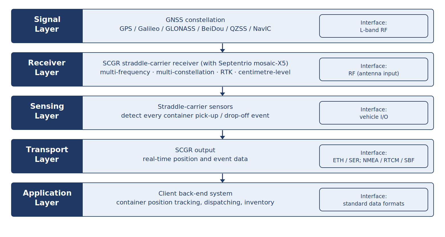
Signal layer to application layer — read “vehicle I/O” as your autopilot interface and “client back-end” as your ground station.
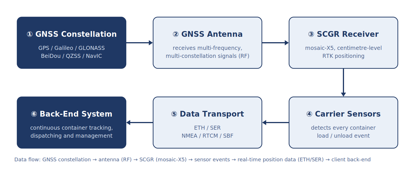
The same chain on a UAV: constellation, antenna (RF), receiver module, event/trigger source, telemetry link, ground control.
- Antenna — multi-frequency, multi-constellation reception on an L-band RF front end; on a drone the antenna placement and ground plane matter as much as the receiver.
- Receiver — the mosaic-X5 module computing the position; on the terminal it is a boxed SCGR unit, on a UAV it is a module on the payload stack.
- Event source — carrier sensors on the ground, camera or trigger input in the air: whatever marks the instant that has to be position-stamped.
- Transport — Ethernet or serial with NMEA / RTCM / SBF on the terminal; on a drone the same stream goes to the autopilot and the telemetry radio.
- Application — dispatching, inventory and management on the ground; mission logging, geotagging and corridor adherence in the air.
Six capabilities that transfer directly to drones
| Capability | What it does | Where it matters on a UAV |
|---|---|---|
| Multi-frequency, multi-constellation tracking | Uses GPS, Galileo, GLONASS, BeiDou, QZSS and NavIC together | More usable satellites in a blocked skyline; fewer hover drifts |
| APME+ multipath suppression | Separates direct signal from reflections | Reflections off buildings, containers, vessels and hangars |
| AIM+ anti-jamming / anti-spoofing | Suppresses narrowband, wideband and pulsed interference | Contested or noisy RF; fewer RTK drop-outs |
| LOCK+ vibration-robust tracking | Holds tracking through impact and heavy vibration | Airframe vibration, hard landings, gimbal-induced motion |
| IONO+ / RAIM+ | Ionospheric monitoring and autonomous integrity | Long-range and BVLOS operations where integrity must be argued |
| 100 Hz update with centimetre-level RTK | High refresh rate, low latency | Control-loop accuracy for inspection, delivery and mapping |
Choosing the module or receiver for an unmanned platform
The mosaic-X5 module measures 31 × 31 × 4 mm and weighs under 7 g on ultra-low power, which is what makes
it practical to fit inside a payload bay rather than hanging off the airframe. For teams that want a finished receiver
instead of a module, two families cover most drone work.
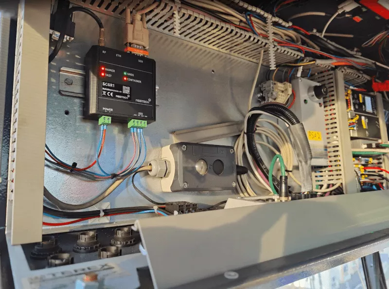
A boxed receiver installed in a machine control cabinet — the same integration problem, solved on a vehicle instead of an airframe.
HBEV322 / HBEV322H — RTK receiver for UAV payloads, Septentrio mosaic-G5 P3H inside
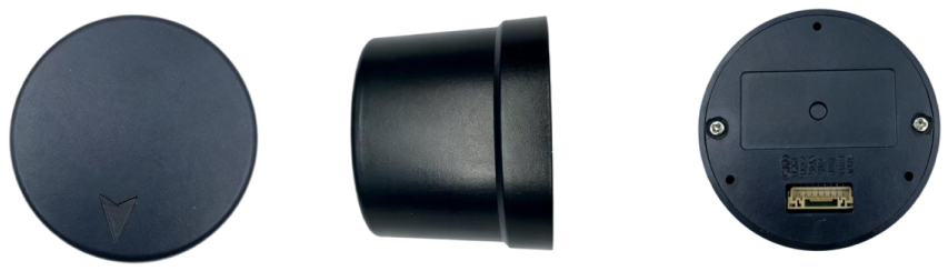
HBEV322 / HBEV322H — top, side and bottom views.
- Septentrio mosaic-G5 P3H module, 789 simultaneous channels, GPS / BDS / GLONASS / Galileo / QZSS support.
- RTK of 0.6 cm + 0.5 ppm horizontal and 1 cm + 1 ppm vertical.
- Dual-antenna heading — 0.15° at a 1 m baseline, 0.25° roll/pitch — plus a QMC5883L compass for a heading reference even at low speed or hover.
- 1–20 Hz update rate, NMEA 0183 and RTCM v3.x output, 8-pin GH1.25 connector.
- φ44 × 40.6 mm, 14 g, under 800 mW — small enough for a compact multirotor.
HB50 / HB56 / HB50H / HB56H — multi-frequency RTK receivers, Septentrio Inside (HB50 / HB56 up to 100 Hz)
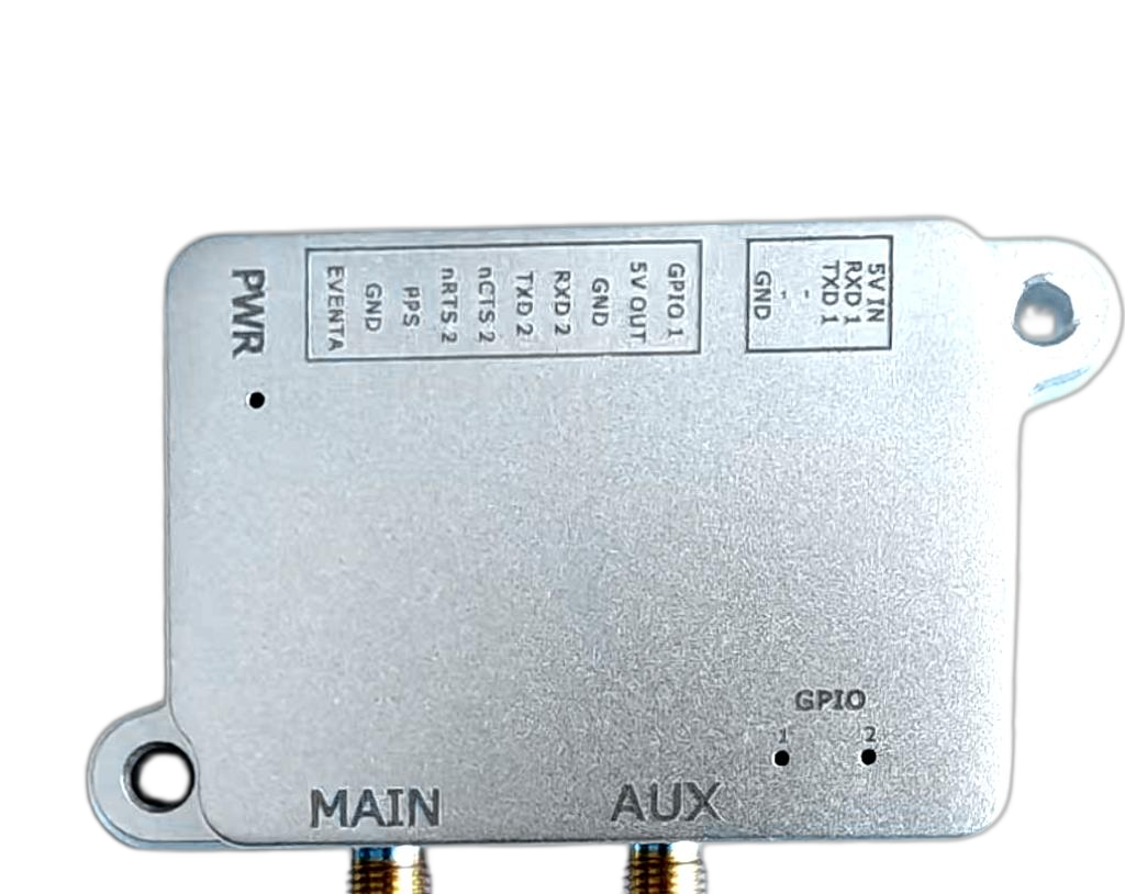
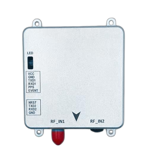
HB50 / HB56 (left) and HB50H / HB56H (right).
- Up to 100 Hz on HB50 / HB56 and up to 20 Hz on HB50H / HB56H.
- RTK of 0.6 cm + 0.5 ppm horizontal and 1 cm + 1 ppm vertical across GPS, GLONASS, BeiDou, Galileo, QZSS, NavIC and SBAS.
- Dual-antenna heading with roll and pitch output, same 0.15° / 0.25° figures at a 1 m baseline.
- AIM+, IONO+, APME+, LOCE+, RAIM+ and OSNMA support.
- 7.6 × 6.9 × 1.3 cm and 60 g at about 1.6 W, or 5.9 × 4.4 × 1.2 cm and 50 g at 0.44–0.60 W on the H-variants.
Integration checklist for drone teams
- Mount the antenna properly first — a clear view and a correct ground plane buy more accuracy than any receiver setting.
- Decide the loop rate before choosing the receiver — 20 Hz is usually enough for logging, 100 Hz matters when the autopilot closes on position.
- Budget for the multipath case, not the open field — test where you actually fly, not on a clear test range.
- Keep a vibration-robust tracking mode available — airframe resonance is the same problem as machine impact.
- Verify RTK behaviour at the edge — watch how long fix holds when the correction link or the sky degrades.
- Plan the swap like an operation, not a bench test — the port unit was replaced with zero downtime; a live inspection fleet deserves the same plan.

MSC PSA European Terminal (MPET), Port of Antwerp: the environment the receiver was re-engineered for.
What the deployment numbers say
Centimetre-level RTK at up to 100 Hz, a full re-design delivered in under three months, and a terminal that never
stopped working. For a UAV programme, those three lines are the realistic envelope to expect when you are changing a
positioning payload on a platform that cannot afford a pause.
Sources
- MGB-Tech Positioning — mgb-tech.com / pos.mgb-tech.com
- Septentrio mosaic-X5 product documentation
- Original customer story “Robust Positioning PSA Port Logistics”
FAQ
Why should a drone team care about a container-terminal deployment?
Because the receiver conditions are the same. A carrier working between stacked containers sees a partly blocked sky and a dense field of reflected signals, which is exactly what a drone meets between buildings, over a vessel or inside an industrial yard.
What actually breaks GNSS on a UAV in a multipath environment?
Not the number of satellites alone, but the mix of blocked sky and reflected signals. Reflections arrive with a delay and can pull the position estimate, which is why a receiver with dedicated multipath suppression holds centimetre repeatability longer than one without it.
Is 100 Hz update rate really needed on a drone?
For position logging, no. For anything closing a control loop — precision landing, inspection hold, delivery drop, gimbal pointing, tight mapping lines — a 100 Hz position stream reduces the lag the flight controller has to compensate for.
How does anti-jamming and anti-spoofing help in normal flight?
AIM+ suppresses narrowband, wideband and pulsed interference and adds spoofing protection. In practice that means fewer position losses and fewer RTK drop-outs when you fly near RF sources you do not control.
Which modules and receivers fit an unmanned platform?
The Septentrio mosaic-X5 module at 31 × 31 × 4 mm and under 7 g, the HBEV322 / HBEV322H receiver with dual-antenna heading and built-in compass, and the HB50 / HB56 family — up to 100 Hz on HB50 / HB56 and up to 20 Hz on the H-variants.
What does the port deployment prove about uptime?
That the re-engineered unit was delivered in under three months without stopping terminal operations — a useful benchmark when you are planning a receiver swap on a live platform.
Related reading
The full port logistics case study — including the straddle carrier architecture and the comparable receiver options — is published on gnss-solutions.com: Port Logistics Positioning That Survives Steel.